Although Brazil is a vast and diverse country, it lacks certain notable natural elements. Other elements are present, but they appear with limited frequency, size, or characteristics, often in a subtle or insignificant manner. In this post, we will explore both of these types of elements.
Some elements occur in Brazil with very low frequency, extent, level, or intensity, and therefore cannot be considered absent. This list includes upwellings (Brazil does not have any of the world's largest, but it does have one of its own in Rio de Janeiro), major earthquakes (the largest in the country reached only 6.7ºR, in Amazonas), lava tubes (only in Paraná state), giant caves (the largest Brazilian cave is only the 22nd largest in the world), kelp forests (there is a small community in Espírito Santo), coral reefs (found in the Northeast), large islands (the largest is just the small Florianópolis, 424 km²), a super-humid region (one exists in Amapá), hurricanes (only one historical record in Santa Catarina), and sandstorms (reported in the 2000s). Information on these topics can be found in BRAZIL NATURE, LOCATION AND POSITION and BRAZIL IN 74 TREASURES.
ELEMENTS FULLY ABSENTS IN BRAZIL
Brazil's tropical location, very low tectonic activity, geological history, isolated position in the eastern part of South America, and homogeneous coastline indeed result in many geographic exotemas. In this post, let's list Brazil's 22 canonical exotemas.
TECTONICS AND CAVES
1 EXPOSED FAULTS ‣ there is no formal and academic listing of exposed partition faults. Here we limit ourselves to mentioning the most important ones (and highlighting that none are evident from Brazil): Iceland Fault (SEE), Rift Valley in Africa (SEE) and San Andreas in California, U.S.A. (SEE).
2 ACTIVE VOLCANOES ‣ 531 volcanoes has confirmed eruptions since 1800, in 55 countries and Antartida, 282 only in Indonesia, U.S.A., Japan, Russia and Chile. 74 are in South American. Brazil ho has active volcanoes since Holocene (Smthsonian/Volcanoes by Country). Mexico has 9 active volcanoes since 1800, and 5 since 1960. For Chile the numbers are 34 and 19, respectively; in Russia, 49 and 27; in U.S.A., 63 and 40, almost all in Alaska; for a complete synopsis of volcanoes worldwide, see Cottrell (Chapter Book, 2015).
Mainland Eurasia has active volcanoes only in Italy, Greece and Vietnam. Almost all African active volcanoes are provided by hotspots.

VOLCANOES WITH ACTIVE ERUPTIONS SINCE THE YEAR 1800 (BLACK), GEYSERS (BLUE) AND HYDROTHERMAL VENTS WORLDWIDE (PINK)
3 GEYSERS ‣ a geyser is a spring characterized by an intermittent discharge of water ejected turbulently and accompanied by steam. As a fairly rare phenomenon, the formation of geysers is due to particular hydrogeological conditions that exist only in a few places on Earth. Worldwide true geysers occur in 25 countries, two in Europe (Iceland and Turkyie), four in Africa (Chad, Ethiopia, Kenya, Uganda), seven in Asia (India, China, Myanmar, Thailand, Indonesia, Russia, Japan), five in Oceania (New Zealand, Papua New Guinea, Solomon Is., Fiji, Vanuatu) and seven in America (U.S.A., Mexico, Costa Rica, Peru, Bolivia, Argentina and Chile), by Scot Bryan (BOOK, 2018).
For New Zealand gysers, see Johnstons Achive.
4 HYDROTHERMAL VENTS ‣ since the first discovery of vents in 1977, some 700 hydrothermal vent species previously unknown to science (Vents Database), together with 600 species at cold seeps, have now been described (German et al., Plos One, 2011). Worldwide this places occur in over Pacific Ocean, scarce points in Indian Ocean, Red Sea, Mediterrânean, Arctic, and in Meso-Atlantic Ocean The closest occurrences to Brazil are c. 2,500 km away, in the middle of the Atlantic at the same latitude of Pernanbuco, Paraíba and Rio Grande do Norte; for details about this vent, see German et al. (Earth and Planetary Sciences Letters, 2008).
5 GYPSUM CAVES ‣ open gypsum karsts are found mainly in arid and semiarid environments, and where fairly thick gypsum units were surrounded by impervious sequences prior to exposure. The best documented examples of caves formed in open karst type are in Central Apennines and Sicily in Italy (Neogene gypsum), in Sorbas (Neogene gypsum) and Vallada (Triassic gypsum) regions in Spain, in New Mexico and in Oklahoma, USA (Permian gypsum), and in the Pinega region of NW Russia (Permian gypsum). They include the longest gypsum caves of this type: Kulogorskaja-Troja (Pinega, NW Russia, 16.4 km long), Jester Cave (Oklahoma, 11.8 km long), Spipola/Aquafredda (central Apennines 11 km long and 118m deep), Gueva de Aqua (Sorbas, 9.1 km long), and the deepest gypsum cave in the world Tunel dels Sumidors (Vallada; 210m deep). Other significant gypsum caves of this type are explored in the Diebel Nador and Oranais areas in eastern and western Algeria, in the Ar Rabitat/Bir area in northwest Libya, in central and northern Somalia, in some mountain areas in the northern Caucasus in Russia, and in Central Asia in Tajikistan (White & Culver, Enciclopedia of Caves, 2019, 3th edition).
6 ANCHIALINE CAVES ‣ anchihaline (or anchialine) habitats are water bodies in hollows along the sea coasts where the influence of the sea may be felt and which are inhabited by some obligatory subterranean species. Or, more accurately, they belong to 'a tidally influenced subterranean estuary located within crevicular and cavernous karst and volcanic terrains that extends inland to the limit of seawater penetration'. In New World anchialine caves occur in Caribbean, Mexico, America Central, Venezuela, Bermudas, Florida, Galapagos Is. and Hawaii. For diversity of life in anchialine caves, see Perez-Moreno et al. (International Journal of Speleology, 2016). For anchialine caves in Bermudas, see Iliffe & Gutiérrez (Diversity, 2021).
Globally, crustaceans represent the most diversified group of anchialine fauna, with at least 500 species described, belonging to 4 classes, 16 orders, and 57 families. Several taxonomic groups of crustaceans, including the class Remipedia, the peraccharides of the orders Mictacea and Bochusacea, and the copepods of the order Platycopioida have been designated from specimens collected in this medium and are found exclusively in groundwater (Romero, Anartia, 2019).

In Mexico, anchialine caves are only known in the Yucatan Peninsula, with over 2,241 cenotes recorded; a half of this sysmtems have records for only one to three species, five caves with more than ten records, while only three an chialine systems possess representatives of more than two phyla. Despite an apparently low diversity in this region, Calderón-Gutiérrez et al. (2017) performed an exhaustive diversity survey at El Aerolito cenote, which extends for 18 km, and reaches a maximum depth of 27 m. They reported that El Aerolito cave system holds 100 species (53 as new records, and 47 previously reported), grouped within 10 phyla (Porifera, Cnidaria, Platyhelminthes, Nemertea, Sipuncula, Annelida, Arthropoda, Mollusca, Echinodermata, and Chordata). These authors pointed out that El Aerolito is the richest and foremost biodiverse anchialine system of the world, and it could be a result of the energy input to the system by mangroves in the main entrance, and the direct connection with the sea, together with the chemosynthesis processes that occur there (Romero, Anartia, 2019). Details for Mexican anchialine caves, see Alvarez et al. (Mexican Fauna in Anthropocene, 2023).

In Venezuela, so far, only two endemic anchialine species, Cyathura univam Botosaneanu 1983 (Isopoda: Anthuridea) and Metaniphargus venezuelanus Stock & Botosaneanu 1983 (Amphipoda: Hadziidae), have been reported, and they were described from specimens collected in a cave not yet officially record- ed by professional speleologists in Falcon state, specifically in the Mallorquines karst (Botosaneanu’s Cave, Morrocoy peninsula). These two species are the only representatives of their respective groups in South America and they were the result of the 1982 Amsterdam Expedition to the Venezuelan Islands and other localities on the mainland (Romero, Anartia, 2019).
7 CHEMOAUTOTROPHIC CAVES ‣ undeground ecosystem sustained by in situ chemoautotrophic primary production are very rare in Earth surface, and no had a formal checklist. Some classic exmaples are Movile Cave (E, Romania the most iconic, EZJ), Frasassi (Marche, Italy, SEE), Ayyalon (Israel, SEE), Villa Luz Cave (Tabasco, Mexico), Melissotrypa Cave (Elassona municipality, Greece), Tashan Cave (Iran), caves in the Sharo-Argun Valley in the Caucasus Mountains in SE Russia, and Lower Kane Cave and Cesspool Cave (Wyoming and Virginia, USA), by Wikipedia/Villa Luz Cave.
RELATED TO LATITUDINAL POSITION
8 SNOW WINTERS/BLIZZARDS ‣ as a tropical country, Brazil does not have severe winters, with regular temperatures that are always positive, with negative national records almost never lasting more than 24 hours. Blizzards are also very rare. In addition to tropicality, the fact that the Southern Hemisphere is more covered by oceans makes the existence of such winters, and the landscapes and phenomena associated with them, difficult.

WINTER COVERAGE THROUGHOUT THE YEAR, HIGHLIGHTING WHERE THE RIGOROUS WINTER ADVANCES IN THE NORTHERN HEMISPHERE
9 MIDNIGHT SUN, AURORAS, NACARATE CLOUDS AND OTHER HIGH LATITUDE PHENOMENA ‣ midnight sun is a natural phenomenon that occurs in the summer months in places north of the Arctic Circle or south of the Antarctic Circle, when the Sun remains visible at the local midnight. When the midnight sun is seen in the Arctic, the Sun appears to move from left to right, but in Antarctica the equivalent apparent motion is from right to left. This occurs at latitudes from 65°44' to 90° north or south, and does not stop exactly at the Arctic Circle or the Antarctic Circle, due to refraction; the opposite phenomenon, polar night, occurs in winter, when the Sun stays below the horizon throughout the day (Wikipedia).

ARCTIC COUNTRIES, WHERE THE NORTHERN MIDNIGHT SUN OCCURS
Also commonly known as the polar lights, auroras are natural light display in Earth's sky, predominantly seen in high-latitude regions (around the Arctic and Antarctic). Auroras display dynamic patterns of brilliant lights that appear as curtains, rays, spirals, or dynamic flickers covering the entire sky. Aurora australis is visible from high southern latitudes in Antarctica, Chile, Argentina, South Africa, New Zealand, and Australia. Aurora borealis is visible from being close to the center of the Arctic Circle such as Alaska, Canada, Iceland, Greenland, Norway, Sweden, Finland and Russia. On rare occasions the aurora borealis can be seen further south, for example in Estonia, Latvia, Lithuania, Scotland, Ireland, Denmark, and the northern part of the contiguous U.S.A. (Wikipedia).

10 FJORDS ‣ a fjord or fiord is a long, narrow inlet with steep sides or cliffs, created by a glacier. Fjords exist on the coasts of Alaska, Antarctica, British Columbia, Chile, Denmark, Germany, Greenland, the Faroe Islands, Iceland, Ireland, Kamchatka, the Kerguelen Islands, Labrador, Newfoundland, New Zealand, Norway, Novaya Zemlya, Nunavut, Quebec, the Patagonia region of Argentina and Chile, Russia, South Georgia Island, Tasmania, United Kingdom, and Washington state. Norway's coastline is estimated to be 29,000 km (18,000 mi) long with its nearly 1,200 fjords, but only 2,500 km (1,600 mi) long excluding the fjords (Wikipedia). Saco do Mamanguá, a ria in southern Rio de Janeiro state in Brazil (Ecobrasil), is sometimes (and erroneously) reported a single tropical fjorde wordwide (Guia Viaje Melhor).

RELIEF ISSUES
11 HIGHLANDS ‣ Brazil has a low average altitude, of only 320m on average In the country the level 1 highl areas (above 1,000m) stand out only to the east of the country and isolated points to the north (Brazil in X-Ray/BRAZIL NATURE, LOCATION AND POSITION), and in the Americas there is more area at this level Canada, U.S.A, Mexico, Colombia, Ecuador, Peru, Bolivia and Argentina In level 3 high areas, Mexico, Dominican Republic, Guatemala, Costa Rica and Panama have only the highest peak regions; Canada and Venezuela more consistent regions; Colombia U.S.A. and Ecuador more sustained regions; and Peru, Bolivia, Chile and Argentina has large areas, supporting true highlands For an interactive map of altitude around the world, see Flood Map.
12 ABSOLUTE DEPRESSIONS ‣ dozens of land areas of the Earth sit below current sea level, in 33 countries. The lowest land area is the shoreline of the Dead Sea Depression in Israel, Jordan and Syria: approximately 413m below sea level The largest below-sea-level depression by surface area is the Caspian Depression of Kazakhstan and Russia with 200,000 km² of land below sea level (geology.com) In New World absolute depressions are: Lousiana region (-4m), Death Valley in E California (-85,5m), Salton Trough in S California (-69m), Laguna Salada in NW Mexico (-10m), Lake Enriquillo in Dominica Republic (-45m), small places in Lagunillas Municipality, Zulia, Venezuela (up -12m), three places in Piura and Lambayeque Departaments (up -34m), Peru; and areas in coast of Argentina (up -105m). For Argentina provinces, see Wikiwand. Five subjects has areas below sea level (Buenos Aires, Chubut, La Pampa, Rio Negro and Buenos Aires city).

AMERICA LATINA'S NOTES FOR RELIEF, EXCLUDING SURINAME COAST
LAKES AND BASINS
13 ARRHEIC BASINS ‣ no data.
14 ENDORHEIC BASINS ‣ endorheic basins, whose fluvial flow does not flow to the oceans, are typical of continental depressions, and quite common in Eurasia, Africa and Australia. In the Americas there are nine large clusters systems: two in Canada, three systems in the US and Canada, one cluster in Mexico, one in Guatemala, a large system between Peru and NW Argentina, one in Venezuela, and two small systems exclusive to Argentina (Wikipedia). There is no mention of endorheic basins in Brazil.
15 LARGE AND VOLUMOUS LAKES ‣ there are 13 huge lakes in World, simultaneously with more than 8,300 km² in area and 850 km³ in volume (Wikipedia), being 4 in Great Lakes of North America (Superior, Michigan, Huron, Ontario), 3 in E Africa (Tanganika, Malawi and Victoria), two in NW Canada (Great Bear, Grat Slave), two in Eurasia (Caspian, the larger in both aspects, and Baikal), one in South America (Titicaca, the smaller of all huge laks in both aspects) and one in Antartida (Vostok).
16 COLORFULL LAKES AND RIVERS ‣ pink lake is a lake that has a red or pink colour. This is often caused by the presence of salt-tolerant algae that produces carotenoids, such as Dunaliella salina, usually in conjunction with specific bacteria and archaea, which may vary from lake to lake. The most common archaeon is Halobacterium salinarum (Wikipedia).

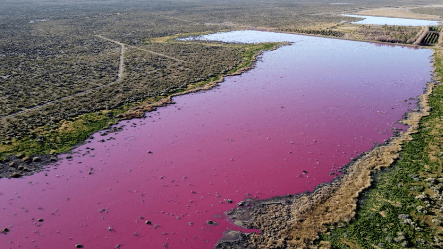


Caño Cristales is a river located in the Serranía de la Macarena, an isolated mountain range in Meta Department, Colombia. It is a tributary of the Guayabero River, itself a part of the Orinoco basin, commonly called the 'River of Five Colors' or the 'Liquid Rainbow', and is noted for its striking colors. The bed of the river from the end of July through November is variously colored yellow, green, blue, black, and especially red, the last caused by Rhyncholacis clavigera (P. Royen) B. R. Ruhfel & C. T. Philbrick plants on the riverbed (Wikipedia).

CAÑO CROSTALES, META COLOMBIA
DRY CLIMATES
17 TRUE DESERTS ‣ a desert is a barren area of landscape where little precipitation occurs and, consequently, living conditions are hostile for plant and animal life. The lack of vegetation exposes the unprotected surface of the ground to denudation. About one-third of the land surface of the Earth is arid or semi-arid; this includes much of the polar regions, where little precipitation occurs, and which are sometimes called polar deserts or 'cold deserts'. Deserts can be classified by the amount of precipitation that falls, by the temperature that prevails, by the causes of desertification or by their geographical location (Wikipedia); oasis, salt flats and sandstorms are some elements associated with deserts.
The world's deserts are found in five belts: the western U.S.A. to northern Mexico [1], the coast of Peru to southern Argentina [2], southeastern Africa [3], northern Africa to northern China [4], and Australia [5].

NON POLAR DESERTS IN WORLD
18 OASIS ‣ in ecology, an oasis is a fertile area of a desert or semi-desert environment[1] that sustains plant life and provides habitat for animals. Surface water may be present, or water may only be accessible from wells or underground channels created by humans (Wikipedia). The Atlas Saharan Oasis (SEE) lists 776 oasis across 11 countries: Mauritania (58), Niger (28), Morocco (166), Algeria (180), Tunisia (38), Libya (31), Egypt (11), Saudi Arabia (21), Yemen (73), Oman (168), and the United Arab Emirates (2).
19 SALT PANS ‣ natural salt pans or salt flats are flat expanses of ground covered with salt and other minerals, usually shining white under the sun. They are found in deserts and are natural formations (Wikipedia). There is no global ranking of salars, so the best we can provide here are notable lists: Salar de Uyuni (SW Bolivia), Bonneville Salt Flats (Utah, U.S.A.), Etosha (Namibia), Rann of Kutch (India border with Pakistan), Salt Pan Creek, Salt Pan Cove, the Salt Pans, Lake Eyre, Lake Amadeus (Australia), San Ignacio Lagoon (Baja California, Mexico, SEE) and Salar do Atacama (N Chile, SEE).
RELATED TO COASTAL CONTOUR AND POSITION
20 DOUBLE COAST ‣ Countries with two or three coastlines are uncommon in the world. In total, 23 countries have this feature, which can be grouped into six categories, by Wikipedia (SEE): only Russia, U.S.A. and Canada has three coasts, both with Arctic, Pacific and Atlantic Ocean [1]; Mexico, Guatemala, Honduras, Nicaragua, Costa Rica, Panama and Colombia are all Spanic countries with coasts in Pacific and in Atlantic [2]. South Africa, Chile, Argentina and Australia are tip-countries with two coasts [3]; Thailand, Malaysia, Indonesia and East Timor are provusely mixed with coasts between Indian and Pacific Ocean [4]; Egypt and Israel are Mediterranean/Red Sea coas countires [5]; and Norway, Iceland and Greenland are Artic/Atlantic countries [6].
21 PENINSULAS, SEAS and GULFS ‣ a peninsula is a landform that extends from a mainland and is surrounded by water on most, but not all of its borders; a peninsula is also sometimes defined as a piece of land bordered by water on three of its sides; peninsulas exist on all continents; the size of a peninsula can range from tiny to very large. The largest peninsula in the world is the Arabian Peninsula (Wikipedia).
This concept is subjective and may include quite controversial elements. The blog Brazil in X-Ray will adopt its own definition of a peninsula here, referred to as Peninsula Senso BIXR: landmasses extending from a larger continental mass, without a defined triangular shape, that exhibit an intuitive notion of an isthmus and have significant cartographic prominence on a global scale.
Under the terms above, only 19 peninsulas are considered in the world: Antarctica, Yucatán, Baja California, Florida, Labrador, Melville, Alaska, Nome, Brittany, Jutland, Scandinavia, Kola, Italic, Peloponeso, Crimea, Arabian, Malay, Korean, and Kamchatka.
Some classic peninsulas are rejected here: Iberian, Carpentaria, Indian, and the Horn of Africa. Peninsulas on islands, such as those in Sulawesi, are also excluded.
Here is no clear definition of what is bay, gulf or sea; in this way, there are bays larger than seas, lakes called sea, gulfs more open than coasts that do not take any special name, assigned to classical, media or historical names. On the map below we highlight all the major maritime bodies in these categories, with the notable highlight that there are almost none of these in South America.
RELATED TO BIOLOGY
22 HUGE ANIMAL MIGRATIONS ‣ monarch butterfly (Danaus plexippus L., 1758, Nymphalidae) has the longest migration trajectory of any insect; every November, the forest located between the Mexican states of Michoacan and Estado de Mexico is covered in fluttering orange, black, and white insects; as part of their migration cycle, monarch butterflies fly around 2,800 miles from Canada and the United States to spend the coldest months of the year in warmer lands. Brazil no has none massive migration of insects (Travel Leisure).
