21 January 2023

BRAZIL IN X-RAY: A BLOG FOR BRAZIL

Brazil, officially the República Federativa do Brasil, is the largest country in South America and in America Latina. At 8.5 M km² and with over 217 M people, Brazil is the world's 5-largest country by area and the 7-most populous. Its capital is Brasília, and its most populous city is São Paulo. The federation is composed of the union of the 26 states and the Federal District. It is the only country in the Americas to have Portuguese as an official language. It is one of the most multicultural and ethnically diverse nations, due to over a century of mass immigration from around the world, and the most populous Roman Catholic-majority country (Wikipedia).

Brazil is an incredible country, although it is and is super stigmatized. In this blog we bring a refined and symbolic approach to several elements of the national reality, abundantly illustrated and seeking to close some gaps in available information.
TERESINA, PIAUÍ, BRAZIL

18 January 2023

BRAZIL: NAME AND ADMINISTRATIVE NOTES

'Brazil' likely comes from the Portuguese word for brazilwood, a tree that once grew plentifully along the Brazilian coast. In Portuguese, brazilwood is called pau-brasil, with the word brasil commonly given the etymology "red like an ember," formed from brasa ("ember") and the suffix -il (from -iculum or -ilium). As brazilwood produces a deep red dye, it was highly valued by the European textile industry and was the earliest commercially exploited product from Brazil. Throughout the 16th century, massive amounts of brazilwood were harvested by indigenous peoples (mostly Tupi) along the Brazilian coast, who sold the timber to European traders (mostly Portuguese, but also French) in return for assorted European consumer goods. The official Portuguese name of the land, in original Portuguese records, was the "land of the Holy Cross" (Terra da Santa Cruz), but European sailors and merchants commonly called it simply the "land of Brazil" (Terra do Brasil) because of the brazilwood trade. The popular appellation eclipsed and eventually supplanted the official Portuguese name. Some early sailors called it the "land of parrots". In the Guarani language, an official language of Paraguay, Brazil is called "Pindorama". This was the name the indigenous population gave to the region, meaning "land of the palm trees" (Wikipedia, SEE).

Brazil is a federation composed of 26 states, one federal district, and the 5,570 municipalities. The Union, the states, the Federal District, and the municipalities, are the 'spheres of government'. The federation is set on five fundamental principles: sovereignty, citizenship, dignity of human beings, the social values of labor and freedom of enterprise, and political pluralism. The classic tripartite branches of government (executive, legislative and judicial under a checks and balances system) are formally established by the Constitution. The executive and legislative are organized independently in all three spheres of government, while the judiciary is organized only at the federal and state and Federal District spheres. All members of the executive and legislative branches are directly elected. For most of its democratic history, Brazil has had a multi-party system, with proportional representation. Voting is compulsory for the literate between 18 and 70 years old and optional for illiterates and those between 16 and 18 or beyond 70. The country has more than 40 active political parties. Fifteen political parties are represented in Congress. It is common for politicians to switch parties, and thus the proportion of congressional seats held by particular parties changes regularly.

Brazilian states vary greatly in population and area, ranging from states with just over half a million inhabitants (Roraima state, with 652,713, IBGE) to over 45 M (São Paulo state, 46,649,132 by IBGEthe most populous sub-unit in the New World and the 27th in the world, by FANDON); in area, it ranges from small states with less than 25,000 km² (Sergipe state, with 21,938.188 km²) to the great Amazonas state, with more than 1.5 M km² (1,559,255.881 km², the 9th largest sub-unit in the World, by Wikipedia).

BRAZILIAN LAYERS OF ADMINISTRATION

Brasília is the capital of Brazil and the 3th largest city in the country, with 3,039,444 in. Administratively and territorially Brasília and the Federal District are equivalent; this entity, when interpreted at in the interpretation of municipality, as in the ranking of largest cities, is Brasília. When interpreted from a state perspective, as in the case of being the smallest federative unit in the country, it is the Federal District (Almanaque Z).

The city is located at the top of the Brazilian highlands in the country's Central-West region, at 1,172 m high. It was founded by President Juscelino Kubitschek on 21 April 1960, to serve as the new national capital. Brasília is estimated to be Brazil's third-most populous city. Among major American Latina's cities, it has the highest GDP per capita. Brasília was inscribed as a UNESCO World Heritage Site in 1987 due to its modernist architecture and uniquely artistic urban planning. It was named "City of Design" by UNESCO in October 2017 and has been part of the Creative Cities Network since then (Wikipedia).

BRAZILIAN SOME LOCATIONS AND PLACES (MAP IN PORTUGUESE). CLICK FOR FULL SIZE
Brazil has 26 state capitals where the headquarters of state governments are located, the parallels of each unit and of many public administration bodies; with the exception of Florianópolis and Vitória, are the largest cities in their respective states. Some capitals are mountainous, some on the coast, in the Amazon, on islands, in the Northern Hemisphere, on the Equator, in the Tropic of Capricorn, in the temperate zone, small megalopolises, with portuguese, spanish, dutch and french foundations. Some superlatives of them are shown on the map below.


15 January 2023

BRAZIL: HISTORY

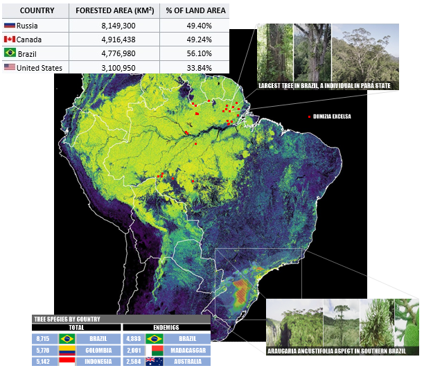
NON-AUTHOR TEXT ALERT: in this post we have copied the text from Wikipedia (SEE) about the History of Brazil, a very summarized version, with slight adaptations and images prepared/adapted by Brazil in X-Ray, until 1950. For a fantastic compilation of the evolution of the Brazilian territory, we recommend Panmythica (BLOG, 2008).

Some of the earliest human remains found in the Americas, Luzia Woman, were found in the area of Pedro Leopoldo, Minas Gerais and provide evidence of human habitation going back at least 11,000 years. The earliest pottery ever found in the Western Hemisphere was excavated in the Amazonas river basin of Brazil and radiocarbon dated to 8,000 years ago (6000 BC). The Marajoara culture flourished on Marajó in the Amazonas delta from 400 CE to 1400 CE, developing sophisticated pottery, social stratification, large populations, mound building, and complex social formations such as chiefdoms; for somes details abouth Amazonean occupation, we recommend Souza et al. (Nature, 2018), about Pre-Columbian earth-builders settled along the entire southern rim of region, and M. J. Heckenberger et al. (Phil. Trans. R. Soc. B., 2007), about the legacy of cultural landscapes in the Brazilian Amazone.
CABRALINE ERA

In 1500, the territory of current day Brazil had an estimated indigenous population of 7M people, mostly semi-nomadic, who subsisted on hunting, fishing, gathering, and migrant agriculture. Before the arrival of the Europeans, the boundaries between these groups and their subgroups were marked by wars that arose from differences in culture, language and moral beliefs. These wars also involved large-scale military actions on land and water, with cannibalistic rituals on prisoners of war.

PORTUGUESE COLONIZATION

Following the 1494 Treaty of Tordesillas, the land now called Brazil was claimed for the Portuguese Empire on 22 April 1500, with the arrival of the Portuguese fleet commanded by Pedro Álvares Cabral. Though the first settlement was founded in 1532, colonization effectively began in 1534, when King John III of Portugal divided the territory into the fifteen private and autonomous Captaincy Colonies of Brazil. In 1549 the city of Salvador began the capital of a single and centralized Portuguese colony in South America; the country lived with Europeans and indigenous people at war and occasional opportunistic alliances, and the sugar cane cycle, which fostered the importation of slave labor from sub-Saharan Africa (mainly Western Africa, Angola and Mozambique). Portuguese Brazil received more than 2.8 million slaves from Africa between the years of 1500 to 1800.

By the end of the 17th century there was a change in the backbone of the colony's economy, declining sugarcane and the gold cycle,which attracted thousands of new settlers to Brazil from Portugal and all Portuguese colonies around the world. Portuguese expeditions (bandeiras) advanced the Portugal colonial original frontiers to approximately the current borders. on the coast, other European groups were trying to occupy parts of Brazil, notably the French (in Rio de Janeiro during the 1560s, in Maranhão during the 1610s) and the Dutch (Bahia and Pernambuco).
SIX OF THE MOST IMPORTANT BANDEIRANTES IN BRAZIL
The two main objectives of Portuguese colonization in Brazil were to keep under control and eradicate all forms of slave rebellion and resistance (e.g. Quilombo of Palmares) and to repress all movements for autonomy or independence (e.g. Minas Conspiracy).

UNITED KINGDOM WITH PORTUGAL

In late 1807, besides hostilities with Spanish and Napoleonic forces, Prince Regent João to move the royal court from Lisbon to Rio de Janeiro, where they established some of Brazil's first financial institutions, ending the Portuguese monopoly on Brazilian trade and opening Brazil to other nations. In 1809, in retaliation for being forced into exile, French Guiana was invaded by Brazil. With the end of the Peninsular War in 1814, the court should return to Portugal; however, to justify his stay in Brazil,, the Crown established the United Kingdom of Portugal, Brazil and the Algarves, a pluricontinental transatlantic monarchic state. By great pressure in Portugal, in 1821, João VI is departed for Lisbon, leaving his son, Prince Pedro de Alcântara, as Regent of the Kingdom of Brazil.

INDEPENDENT EMPIRE

Motivated by tensions between Portuguese and Brazilians, Prince Pedro decided to stand with them, declaring the country's independence from Portugal on 7 September 1822, named 1 month later as first Emperor of Brazil, with the royal title of Dom Pedro I, resulting in the founding of the Empire of Brazil; as a result of the war of independence already spread by northern, northeastern regions and in Cisplatina, the last Portuguese soldiers surrendered on 8 March 1824; Portugal officially recognized Brazilian independence on 29 August 1825.

On 7 April 1831 Pedro I went to Portugal to reclaim his daughter's crown after abdicating the Brazilian throne in favor of his five-year-old son (who thus became the Empire's second monarch, with the royal title of Dom Pedro II). In the absence of a charismatic figure who could represent a moderate face of power, during a regency (motived by small age of son) a series of localized rebellions took place, such as the Cabanagem in Grão-Pará Province, the Malê Revolt in Salvador da Bahia, the Balaiada (Maranhão), the Sabinada (Bahia), and the Ragamuffin War, which began in Rio Grande do Sul and was supported by Giuseppe Garibaldi.

In monarchy, national debate centered on the issue of slavery, with Atlantic slave trade was abandoned in 1850, but only in May 1888, slavery was formally abolished with the approval of the Golden Law; internationally, after the Cisplatine War that resulted in the independence of Uruguay, Brazil won three international wars during the 58-year reign of Pedro II: Platine War, the Uruguayan War and the devastating Paraguayan War, the largest war effort in Brazilian history.


On 15 November 1889 (Republic Day, a national holiday), in disagreement of Imperial Army officers, rural and financial elites, the monarchy was overthrown by a military coup; few days later, the national flag was replaced with the national motto "Ordem e Progresso", influenced by positivism.

EARLY REPUBLIC

The early republican government (until 1930) was nothing more than a military dictatorship, with the army dominating affairs both in Rio de Janeiro and in the states; freedom of the press disappeared and elections were controlled by those in power; internationally, this period maintained a relative balance characterized by a success in resolving border disputes with neighboring countries (for a extraordinary scholarly text on the subject, see De Rezende, Thesis, 2006), only broken by the Acre War (1899–1902) and its involvement in World War I (1914–1918; FEB was the only America Latina military force in World War II).

ERA VARGAS

In Revolution of 1930 the defeated opposition presidential candidate Getúlio Vargas, supported by most of the military, successfully led; supposed to assume power temporarily, Vargas closed down Congress, extinguished the Constitution, ruled with emergency powers and replaced the states' governors with his own supporters. In the 1930s, three failed attempts to remove Vargas and his supporters from power occurred, in 1932, 1935, and in May 1938; the 1937 coup d'état resulted in the cancellation of the 1938 election and formalized Vargas as dictator, beginning the Estado Novo era. Throughout World War II, Brazil remained neutral until August 1942, whaen entered on the allied side. With the Allied victory in 1945 and the end of the fascist regimes in Europe, Vargas's position became unsustainable and he was swiftly overthrown in another military coup, with democracy 'reinstated' by the same army that had ended it 15 years earlier. Vargas committed suicide in August 1954 amid a political crisis, after having returned to power by election in 1950.

12 January 2023

BRAZIL: LOCATION, AREA AND PHYSICAL NOTES

PANGEA present-day Brazil was part of the ancient continent Pangea, a term coined by Alfred Wegener in his 1920 book - including, most visible evidence of this split is in the similar shape of the coastlines of modern-day Brazil and West Africa. According to the probable distribution of the supercontinent, present-day Brazil had land connections with its present-day neighbors and with several West African countries, from Sierra Leone to Namibia; from 550 to 180 M years ago, Brazil was part of Gondwanaland, the southern continent, maintaining its same neighborhood in Pangaea. This continent follows a set of high-intensity events of the Neoproterozoic period, called the Brasiliana Orogeny. A high interest map for similar geology of northern South America and W Africa is available in Steel Club (SEE).


ANTIPODES ‣ most of the world has no antipodes on land. The exception is for South America, East and Southeast Asia, Antarctica and the Arctic region. Much of the Canadian islands, Greenland and a fraction of Siberia are antipodes of Antarctica, including the Antarctic Peninsula. A very significant potion from China is antipodal to Argentina and Chile, Peru antipodal to Indochina, Ecuador antipodal to peninsular Malaysia and Colombia antipodal to Sumatra. Sulawesi is antipode of Guyana and Pará state, while Borneo and the Philippines are antipodes of Brazil, in the states of Mato Grosso, Pará, Roraima and Amazonas.
EXTREMES AND COORDINATES OF BRAZIL ‣ situated entirely in the western hemisphere, the three latitudinal extremes (west, mainland east, over east) of the country are west Greenwich; crossed by the Equator and the Tropic of Capricorn, the northern end of the country is in the Northern Hemisphere, and the southern end is in the southern temperate region. Brazil is the longest country in the world, spanning 4,395 km (2,731 mi) from north to south, and the only country in the world that has the equator and a tropical line (Tropic of Capricorn) running through it.

Northern Hemispheres cover in Brazil c. 601,427 km² (7,062 % of total area), in approximate values in manual measurement of Brazil in X-Ray in Google Earth polygon tool, are in Amazonas (c. 140,600 km² in western portion, 3,960 km² in eastern portion), Roraima (201,347 km²), Pará (128,234 km²) and Amapá (127,286 km²). With same metodology, temperate zone cover a very similar area, 600,935 km² (7,056% of country area) in partial São Paulo (48,319 km²), Mato Grosso do Sul (8,250 km²), and Paraná (167,272 km²), and over Santa Catarina (95,346 km²) and Rio Grande do Sul states (281,748 km²).

N: Monte Caburaí, Roraima (RR, 05°16′10″ N; for details inside a expedition, see Amazonas Abenteuer). 
 
S: Arroio Chuí, Rio Grande do Sul (RS, 33°45′03″ S) 
 
E (over): Ilha do Sul, Ilhas de Martim Vaz, Espírito Santo (ES, 28°50′51″ W). 
 
E (continental): Ponta do Seixas, Paraíba (PB, 34°47′34″ W). 
 
W: Serra do Divisor, Acre (AC, 73°58′59″ W).

The distances of the latitudinal and longitudinal extremes are almost equivalent, with a difference of only 53 km, less than 2% of both (4,379 km N/S, 4,323 km E/W). Interestingly, the continental and W extremes are almost at the same latitude (0º22'48'' difference), which makes the segment that connects them almost coincident with the largest parallel in the national territory (approx. 7º21' S) and also the longest 'straight' line inside Brazilian territory. The longest meridian in the national territory (approx. 53º29' W) is approximately 3,832 km long and is quite distinct from the segment that joins the N and S extremes.The extreme north of Brazil is the 10th most southern of all those in the Northern Hemisphere (SEE); the extreme south of Brazil is the 7th most southern for a sovereign country (SEE); Brazilian extreme west is the 23rd most westerly of all (SEE); finally, the easternmost continental part of Brazil is the 14th easternmost of all the countries that have it west of Greenwich (SEE), and the easternmost of the Americas. For many curiosities for Brazilian territory, see Lista de Extremos do Brasil (Wikipedia).
 
In South America, the continental Pole of Inaccessibility is in Brazil at 14.05°S 56.85°W, near Arenápolis, Mato Grosso, 1,504 km (935 mi) from the nearest coastline (Wikipedia); for technical details, see Castellanos & lombardo (Scottish Geographical Journal, 2007).

BRAZILIAN EXTREMES, LENGHTS OF IMPORTANT LINES, ZONES, AND OTHER REMARKABLE POINTS
LINES IN SEA ‣ from the Brazilian coast, going east, there is the African coast, with Amapá facing Cameroon and Equatorial Guinea, from Amapá to Rio Grande do Norte all facing Gabon, a small fraction of Rio Grande do Norte facing the DR Congo, Rio Grande do Norte to Bahia all facing Angola, from Bahia to Santa Catarina facing Namibia, and from there to Chuí, facing South Africa.
FACING MAPS BETWEEN SOUTH AMERICA AND AFRICA; FOR ALL COLECCTION, SEE RELATIVELY INTERESTING
ATLANTIC BRAZIL ‣ Brazilian coastline measures 7,491 km,which makes it the 15th longest national coastline of the world (Wikipedia, SEE) - c. 8,15% in northern Hemisphere and remaining 91,85% in southern, along 17 states; all the coast lies adjacent to the Atlantic Ocean. A considerable number of geographical features can be found all through the coastal areas, like islands and bays, mainly tropical beaches interspersed with mangroves, lagoons, todal flats, and dunes, as well as numerous coral reefs. Brazilian beaches (2,095 in total) are famous in the world and receive a great number of tourists. The best reference about the Brazilian coastal zone can be consulted at Atlas Geográfico das Zonas Costeiras e Oceânicas do Brasil (IBGE, 2011, SEE).

A recent global remote sensing analysis also suggested that there were 5,389 km² of tidal flats in Brazil, making it the 7ª ranked country in terms of how much tidal flat occurs there (Murray et al., Nature, 2018).

Brazilian Maritime Territory is the exclusive economic zone (EEZ) of Brazil. It is an offshore area of 3.6 M km² on the Brazilian coast (11ª largest in world), rich in marine biodiversity and energy resources, with a size is equivalent to the surface of the Amazone. The area may be expanded to 4.4 M km² in view of the Brazilian claim that was submitted to the United Nations Commission on the Limits of the Continental Shelf (CLCS) in 2004. It is proposed to extend Brazil's continental shelf to 900,000 km² of marine soil and subsoil, which the country will be able to explore. With the extension, the area will become more contiguous, including the areas of Brazilian archipelagos in the South Atlantic. The region with the largest Brazilian EEZ is the Northeast, due to the existence of several islands that are well spaced from each other in a contiguous marine zone; the island of Trindade is too far from the coast for the same to occur (Wikipedia, SEE). Probably the deepest point of the Atlantic in Brazil, within its EEZ, is a unnamed point is located at& 19°38'39.44"S and 26°03'33.86"W, located 355,2 km from Martim Vaz, 1,398 km off Bahia coast, and just 14,8 km from the border of Brazilian EEZ, which had a depth of -5,854m (Almanaque Z).
BRAZILIAN COASTLINE, LENGHT BY STATE, EEZ, OCEANIC ISLANDS, AND TABLES FOR LARGESTS EEZ'S AND COASTLINES WORLDWIDE
Knowledge of Brazil's deep oceans has seen a relative increase in recent years, largely as a result of a partnership with Japanese institutions; for excellent prospecting work on the southeastern coast larf, see several works publicied in 2020 at Deep Sea Research (Editorial, 2017), inc. deep sea works in São Paulo ridge (SEE), Rio Grande Rise (benthic megafauna/SEE and benthopelagic megafauna/SEE), (SEE). Other deep sea works in submersile vehicles includes discoveries of sponges in Amazonas river mouth (Moser et al., Zootaxa, 2022; see also Zenodo). The most complete reference for Brazilian deep sea biodiversity, see the homonymous book, by Sumida et al. (Springer, 2020).

Brazil has five groups with 58 islands in 4 sets of oceanic islands (Serafini, França & Andriguetto-Filho, Journal of Integrated Coastal Zone Management, 2010), more than 100 km from the coast. Fernando de Noronha (PE, 352 km off Rio Grande do Norte, 21 islands/islets) is inhabited and/or used for tourism purposes, with some restrictions; Saint Peter and Saint Paul Archipelago (PE, 940 km off Rio Grande do Norte, 15 islest/rocks, SEE), Rocas Atoll (RN, 231 km off continent, two islands/islets, SEE), Trindade islands (ES, 1,090 km off Espírito Santo state, 5 islands and many rocks, SEEand Martim Vaz island (ES, 1,142 km off Espírito Santo state, 1 island and some rocks), the latters with 20 islands/islets. Together, these islands have 37.3 km² and 3,141 inhabitants. in 2020 (SEE).

For biodiversity in these islands, Rocas Atoll has 18 spp. of insects and 7 of Aracnida (Almeida C.E. et al., Rev. Brasil. Biol., 2000); Fernando de Noronha has three endemic land snails (Salvador et al., Tentacle, 2022) and 453 spp. of insects in 21 orders, mainly Diptera and Coleoptera (Rafael et al., Rev. Bras. Entomol., 2020). Noronha worm lizard is a reptile sister of Caribbean members of this genus (Graboski et al., Mol. Phyl. and Evol., 2019). For data among Collomebola in Brazilian islands, see Lima et al. (Insects, 2021) for Poduromorpha, and Lima et al. (Diversity, 2021) for Entomobryomorpha. At bryophytes, Fernando de Noronha has 31 spp. in 14 genera and 14 families (Fieldguides, 2021), and Trindade has 38 spp., being 20 liverworts, 17 mosses, and one hornwort (Fieldguides, 2022).

BRAZILIAN BORDERS ‣ Brazil has 14,691 km of borders (3th in total lenght) in 10 land borders (11º in this rank and the firt in New World) and also 10 land neighbours (4th in rank, 3th if we only consider France Metropolitan), by Wikipedia (SEE). Administratively, Brazilian borders has 121 border municipalities in 11 states, with c. 730,000 inhabitants and about 1.4 M of km². Brazil also has 9 tripoints, all the six southern in rivers, one in a mountain summit, and two northermost points 'lost' in Amazone. Brazilian border with Bolivia, with 3,403 km, is the 8th longest in the world (Statista). For notes about some tripoints, see BR/GU/VZ (GOV.BR), BR/VZ/CL (X) and BR/BL/PAR (Amboro Tours). To access a list of public documents including treaties, reports, collections, maps, and links regarding Brazil's borders, visit PCDL (MRE).

BRAZILIAN BORDERS, LENGHT BY COUNTRY, MUNICIPALITIES IN LINE AND TRIPOINTS
BRAZILIAN RELIEF ‣ in contrast to the Andes, which rose to elevations of nearly 7,000 meters (22,966 ft) in a relatively recent epoch and inverted the Amazone's direction of flow from westward to eastward, Brazil's geological formation is very old. Precambrian crystalline shields cover 36% of the territory, especially its central area. The dramatic granite sugarloaf mountains in the city of Rio de Janeiro are an example of the terrain of the Brazilian shield regions, where continental basement rock has been sculpted into towering domes and columns by tens of millions of years of erosion, untouched by mountain-building events (Wikipedia). Brazil no has surface below sea level

About 0.5% of the country is above 1,200 m or 3,937 ft, Brazil's Central Highlands include a vast central plateau (Planalto Central); the plateau's uneven terrain has an average elevation of 1,000 meters (3,281 ft). The rest of the territory is made up primarily of sedimentary basins, the largest of which is drained by the Amazonas river and its tributaries. Of the total territory, 41% averages less than 200 meters (656 ft) in elevation (Wikipedia). 
 
Brazil in X-Ray considers that the highest mountains in Brazil are determined by massifs, which rules out the false multiplication of peaks. Based on this understanding, we do not consider Pico 31 de Março as distinct from Pico da Neblina, neither Pico do Calçado and Pico do Cristal as distinct from Pico da Bandeira. In this way, the five highest mountains in Brazil (all over 2,730m), in the opinion of this blog, are the ones that follow below. Brazil highest point (Mount Neblina, 2,992m) is only the 71ª highest in the world (SEE), smaller than the respective for all neighbours except Guianas, Paraguay and Uruguay, evidencing the low altitude of the national territory - by the way, Brazil has only 320m of average altitude, being in position 118 in the ranking of highest countries (SEE). Mount Bandeira (2,892), the second highest mountain in country, is remarkable for being the Brazilian mountain with the greatest topographic isolation: 2,344 km (1,457 miles). In the New World, only Aconcagua, Denali, Pico de Orizaba and Mount Whitney are more topographically isolated than Pico da Bandeira, and in the entire world, there are only 20 more isolated mountains (SEE); a list of the 30 tallest mountains in Brazil is available in Trilhas Conectam (SEE). 
 
The mentioned altitude of Mount/Tepui Roraima below is not that of the top of the mountain, but that of the geodesic mark at the triple point of the borders of Brazil, Venezuela and Guyana; this landmark is the highest point of the mountain that is at least partially in Brazilian territory; the highest point of Mount Roraima as a whole is located in entirely Venezuelan territory (Wikipedia). 
 
To follow a beautiful expedition to the top of Mount Neblina, see SPOT Brasil (YT/2018). 
 
BRAZILIAN FIVE HIGHEST MOUNTAINS
For subterranean places, Brazil has 20,147 caves, being, for example, 8,057 in the São Francisco River basin, 9,225 in the Cerrado, 8,854 in Minas Gerais - numbers that show the Cerrado Mineiro of the São Francisco basin as the hotspot for caves in Brazil (ICMBio, 2019); recent data at CNC/2022. The two largest Brazilian caves in horizontal projection are Toca da Boa Vista (114 km) and Toca da Barriguda (35 km), both in Campo Formoso, Bahia; in depth are Centenário Cave (484 m) and the Bocaina Cave (404 m), both in Mariana, Minas Gerais (Grupo Bambuí). In world has 80 caves with more than 1km of depth, none in Brazil (Profundezas). Riacho Subterrâneo cave in Itu, São Paulo state, is the largest cave in igneous rock of the Southern Hemisphere with approximately 1,500 meters of devel-opment in mapped passageways (Bichuette et al, Neotropical Biology and Conservation, 2017). 
 
Toca da Boa Vista is the longest 22th largest of World and the second in southern Hemisphere after Builita Cave in Australia (Wikipedia).
 
BRAZILIAN SISMIC and VULCANISM ISSUES ‣ no significant incidents like earthquakes, volcanos, and tsunamis occur in Brazil; this is all because of tectonic plates and the location of Brazil within the globe. According to the website Earthquake Track, Brazil experienced 13 earthquakes in the past 365 days. All of them were located on the west side of Brazil, close to Peru and Colombia. In these countries, volcano activity and shock waves are much more common. Also according to the website, most of these earthquakes were considered moderate earthquakes of magnitude around 4.5. Brazil, is not located on the edge of any tectonic plate. The country actually sits right in on top of the South American plate. As greater quakes are observed more often on the edge of the plates, that is why no significant earthquakes occur in Brazil. Researchers state that Magnitude 3 tremors occur twice per month on average in Brazil, while Magnitude 4 tremors happen twice a year. Magnitude 5 tremors, however, only occur once every 50 years in the country (caminhoslanguages.com).

The strongest recent earthquake in Brazil was in Acre state, reaching 6.5º Richter, the second highest in the country's history, with an epicenter more than 100 km from the towns of Tarauacá and Feijó, in Peru border, at a depth of 616 km. It did no damage (UOL); for more details, inc. card below, see Volcano Discovery (LINK). 
 
 
Brazil does not have thermo-seismic manifestations, such as volcanoes, geysers, lava fields or hot springs.

BRAZILIAN CONTINENTAL WATERS ‣ out of all the water on Earth, saline water in oceans, seas and saline groundwater make up about 97% of it. Only 2.5-2.75% is fresh water, including 1.75-2% frozen in glaciers, ice and snow, 0.5–0.75% as fresh groundwater and soil moisture, and less than 0.01% of it as surface water in lakes, swamps and rivers. Freshwater lakes contain about 87% of this fresh surface water, including 29% in the African Great Lakes, 22% in Lake Baikal in Russia, 21% in the North American Great Lakes, and 14% in other lakes (Wikipedia).

Brazil has the largest amount of rivers worldwide, and the largest renowable water resources, with 8,233 km³ (Wikipedia, SEE), followeb by Russia with 4,508 km³. Brazilian waters cover about 55,325 km² of the country (Wikipedia, SEE), the 14ª largest water area in World. 
 
There are 193 rivers over 1,000 km, 39 in Russia, 28 in the US, 24 in China, 22 in Brazil, 14 in Canada and 7 in Australia. The largest rivers that belong to a single country are Yangtze (China), Yellow (China), Lena (Russia), Mackenzie (Canada), Murray (Australia), Volga (Russia), San Francisco (Brazil) and Lower Tunguska (Russia). The three largest rivers in the world that flow into another river are Brahmaputra (India, China, Nepal, Bangladesh, Bhutan), Madeira (Brazil, Bolivia, Peru) and Purus (Brazil, Peru) - for details, see WikipediaAll river flows from Brazil run into the Atlantic Ocean, i.e., Brazil no has endorheic basins. 
 
DIRECTION OF RIVER FLOWS AROUND THE WORLD
Amazonas river, with 6,400 km, is the second longest river in World, after Nile (6,650 km), the largest river by discharge volume of water in the world (1/5 of all riverine discharge to the ocean), greater than the next seven largest independent rivers combined; Amazonas enters Brazil with only 1/5 of the flow it finally discharges into the Atlantic Ocean, yet already has a greater flow at this point than the discharge of any other river (Wikipedia, SEE). São Francisco river is a large river enterely Brazilian, with a length of 2,914 km, the longest river that runs entirely in Brazilian territory, and the fourth longest in South America (Wikipedia). Of the six largest rivers in discharge in the world, 3 are Amazonean, including the Amazonas (209,000 m³/s) and two of its tributaries, the Negro (35,943 m³/s) and Madeira (31,200 m³/s) - see Wikipedia (SEE). Of the top 11 on this list, 7 are South Americans. 
 
For contents about Amazonas souces, visit social media videos: Hema Pelo Mundo (YT/2022) and Espírito Livre Expedições (YT/2021). To view parts of a beautiful flight from Belém to Macapá, over the mouth of the Amazon, visit Bruno Augusto (YT/2021). 
 
SOURCE, ROUTH, MOUTH AND HOT POINTS OF AMAZON RIVER
Brazil has a very scarce number of lakes, the vast majority small and without substantial representation; in short, the types that stand out the most are coastal lagoons. We list here the six of the most prominent in the country. Araruama Lake in Rio de Janiero state is the largest body of permanent hypersaline water in the world, with 220 km², surpassing other prominent hypersaline water bodies such as the Great Salt Lake (United States), Lake Coorong (Australia), Lake Enriquillo (Dominican Republic) and the Lagoon Ojo de Liebre in Mexico (Wikipedia), and the second largest salttwater lake in country and the largest enterely within. Juparanã Lake in Espírito Santo state is the largest (62.58 km², Amorim Gonçalves, Dissertation, 2015) and most volumous (0.5281 km³, estimative of Almanaque Z, SEE) freshwater lake enterely in Brazil, and second of both features in country, in both cases after Mirim Lake. Palmas Lake in Espírito Santo state has maximum depth of 50.7 m, a volume of 0.22 km³ and a mean depth of 21.4 m, being the deepest natural lake in Brazil (Plos One, 2014). Mirim Lake is a freshwaater lake, the largest lake in Brazilian territory, with average are c. 3,749 km² (3,381 - 3,863 km²), c. 2/3 in Brazil and 1/3 in Uruguay (Wikipedia); has an average depth of 4.5 m (Munar et al., SBRH, 2017; maximous of 16m), accumulating, based on these numbers, a average of volume of 16.87 km³ (IPH, 1998). Mangueira Lake is a saltwater in SE Rio Grande do Sul state has c. 820 km² and c. 0.7 km³ of volumen, the largest saltwater lake for Brazil (Artioli et al., Iheringia, 2009). Salgado's Lake in northern Rio de Janeiro state contains the unique ocurrence of recent columnar carbonate stromatolites of whole of Brazil and probably of the South America (SIGEP). 
 
IMAGES, LOCATION AND SHAPE OF 5 MOST NOTABLE LAKES IN BRAZIL
Guarani Aquifer System (GAS) represents the second largest aquifer in the world (after Great Artesian Basin, in Australia, SEE) and the largest in Brazil, occupying 950,000 km² within the Paraná sedimentary basin at 8 states, reaching also in other three countries: Argentina, Paraguay, and Uruguay; 90 M people are directly or indirectly benefitting from the GAS exploitation (Teramoto, Gonçalves & Chang, Journal of Hydrology: Regional Studies, 2022).


426 freshwater ecoregions cover virtually the entire non-marine surface of the earth (MAP), 24 in Brazil, the smallest in Brazil is the Chaco, with a small portion in Mato Grosso do Sul state.

BRAZILIAN CLIMATE ‣ despite the wide latitude and the relative variety of temperatures and rainfall rates throughout the national territory, Brazil is not a country of climatic extremes. In few words, the south of the country has higher records of cold temperatures, while the northeast has a history of low rainfall.
KÖPPEN CLIMATE TYPES OF BRAZIL
The driest place of Brazil is possibly Cabaceiras municiality in Paraíba state, with an average of 336.6 mm with 86 years of observations; during the 86 years studied the total annual extreme rainfall were recorded in the year 1964 in which it rained 775.5 mm and 1952 when the annual total recorded was 23.8 mm (Carmem T. Breckam et al., Rev. Educ. Agrícola Superior, 2013). 
 
ARID REGIONS WORLDWIDE AND BRAZILIAN SEMIARID REGION
The rainest place in Brazil in Calçoene municipality, in Amapá state, with 4,165mm rainfall by year (EMBRAPA). Brazil is the 43th rainest country worldwide, with a average by year/by area of 1,761mm (Global Economy). Oliveira, L.L. et al. (IEPA/AP, 2007), analyzing data from station 825002 in Calçoene, between 1975 and 2006, found an average of 4,238.3mm annually, above the value most commonly reported for the point.
 
The highest temperature officially registered in Brazil was 44.8 °C (112.6 °F) in Nova Maringá, Mato Grosso state, on 4 and 5 November 2020 (terra.com); the lowest temperature officially recorded in Brazil was −14 °C (7 °F) in Caçador, Santa Catarina state, on 11 June 1952 (CIRAN/EPAGRI). There are frosts south of the Tropic of Capricorn during the winter (June–September). 
 
Brazil's cold record is less extreme than that of mostly tropical countries like Botswana, Mexico, Peru and Australia; in turn, the heat record is less extreme than that of essentially temperate non-desert countries such as Azerbaijan, Myanmar, Nepal, Turkey, Bosnia and Herzegovina, Bulgaria, Cyprus, France, Greece, Italy, North Macedonia, Portugal, Russia, Serbia, Spain, Canada, as well as the records of Argentina, Bolivia, Paraguay and Guatemala (Wikipedia). 
 
BRAZILIAN EXTREME CLIMATE PLACES
Because the South Atlantic basin is generally not a favorable environment for their development, Brazil has only rarely experienced tropical cyclones. The country's coastal population centers are considered less burdened with the need to prepare for cyclones, as are cities at similar latitudes in the United States and Asia. In 2011, the Brazilian Navy Hydrographic Center started assigning official names to tropical and subtropical cyclones that develop within its area of responsibility, which is to the west of 20°W, when they have gained sustained wind speeds of 65 km/h and over. Hurricane Catarina is the first and only South Atlantic tropical cyclone to have reached hurricane strength, and impacted Santa Catarina as a Category 2 storm in March 28, 2004. It reached sustained wind speeds of 155 km/h and a pressure of 972 millibars. The hurricane damaged shipyards and several crop fields, and poorer people were affected the most. At least 2,000 people became homeless as a result of the storm (Wikipedia).
HISTORIC SERIES OF HURRICANES, IMAGE AND WAY OF OF CATARINA HURRICANE, UNIQUE IN RECENT HISTORY OF BRAZIL
Snow in Brazil often happens in winter in the mountains of Rio Grande do Sul, Santa Catarina, and Paraná, and is rarer at lower elevations. It is possible, but very rare, in the states of São Paulo, Rio de Janeiro, Minas Gerais, and Mato Grosso do Sul. The greatest snowfall recorded in the country occurred in Vacaria on 7 August 1879, when more than 2 metres (79 inches) of snow accumulated on the ground. Other significant snowfalls where more than 1 metre (39 inches) of snow accumulated happened on 20 July 1957 in São Joaquim and 15 June 1985, in Pico das Agulhas Negras. São Joaquim has the most snowy days of any settlement in Brazil. Snow has been recorded in Curitiba during several years, but has not accumulated significantly since 1975. In 2013, snow hit several municipalities, including Curitiba. Snow has also occurred in Porto Alegre, but is very rare (Wikipedia).

SNOW FALL IN THE NORTHEAST OF RIO GRANDE DO SUL STATE IN JULY 28, 2021
Lightning in New World are centered in NW South America (Ecuador to Venezuela) and Chaco region from Argentina to Paraguay; in Brazil, the hottest point is Mato Grosso do Sul region. The second world’s greatest extent for a single lightning flash is a single flash that covered a horizontal distance of 709 ± 8 km across parts of southern Brazil on 31 October 2018 (WHO). 
 
WORLD MAP OF LIGHTNING ACTIVITY (NEW SCIENTIST) AND MAP OF THE SECOND MEGAFLASH LIGHTNING EVE RECORDED (PUBLIC/WMO)
VEGETATION MOSAIC  a very common discussion in geography is to analyze the 'vegetation' of a place. Here we will work with ecoregions, large units of land or water containing a geographically distinct assemblage of species, natural communities, and environmental conditions (WWF); a huge map of land and marine ecorregions, see images.takeshape, and a oficial article is available in BioScience, 2017 (SEE). Brazil has 78 ecorregions, all listed on the map below (a list available in Wikipedia/List of ecoregions in Brazil). Brazil's ecoregions vary greatly in appearance and physiognomy. The smallest are those on oceanic islands, coastal formations, and high-altitude savannas. Despite the ecoregions, numerous maps propose to catalog the vegetation of Brazil; the most realistic, in the opinion of this blog, is the one proposed below, whose origin cannot be verified.
BRAZILIAN VEGETATION FORMATIONS
The world has c. 40,589 mi km² of forests, c. 1/5 in South America and c. 1/8 in Brazil, with 4,966,200 km², the third largest forest cover of the world, mainly in Atlantic coast and Amazone (Wikipedia, SEE). Based on the figures in this reference, from 1990 to 2020, Brazil lost 922,780 km² of forests, about 15.66% of the total cover. Brazil has also the largest amount of species of trees, with 8,715 spp., and by endemic species of trees, with 4,226 spp. (BGCI). The tallest tree in Brazil and in South America is Dinizia excelsa Ducke (Fabaceae): a specimen with an unbelievable 88.5m in height, in a remote region of the Paru State Forest, in Pará state; this tree is the 10th tallest in the world, the 2th largest tree in the tropical region of Earth, the largest non-Malvid angiosperm, and the largest angiosperm in the New World (Siderasis).

TROPICAL FORESTS IN SOUTH AMERICA, SOME DATA, DISTRIBUTION OF DINIZIA EXCELSA AND CONIFERS

BIODIVERSITY ‣ Brazil is one of the most biodiverse countries in the world, a situation largely favored by the fact that it has the largest area in the tropical zone of the entire planet. The following is a general synopsis of the national diversity in the two most notorious groups: vascular plants and animals.

ANIMALS (in 22 JAN, 2024)

With data from the Brazilian Metazoa website (SEE), Brazil has 126,308 spp. of animals in 26,411 genera, these belonging to 3,410 families at 30 phylla. c. 73% of the animals in Brazil are insects, distributed in 15,716 genera and 684 families. This represents 1/13 of the world's animal diversity. 
 
Some numbers in Brazil includes 91,150 insecta, 9,070 Arachnida, 4,543 bone fishes, 2,737 gastropoda, 1,679 breed birds, 1,675 Neodermata and 1,429 Nematoda, among others. Coast of Brazil includes c. 1,817 gastropoda, c. 1,197 Annelida, 769 Cnidaria, 545 sponges, 347 Echinodermata and 330 Bryozoa. Brazilian freshwaters includes 3,502 fishes, 117 gastropoda, 116 bivavia, 61 tardigrada, 53 sponges, 16 Bryozoa and six Cnidaria, among others. 
 
Brazil has 643 spp. of troglobitic species (exclusive to caves, SEE), being the 5th richest in the world outside Europe (after U.S.A., Australia, China and Mexico), in several groups, being one of the few countries with species in some phyla, such as Porifera and Onychophora, in addition to other smaller groups, such as Bivalvia. 
 

Vertebrates are the most emblematic groups to discuss fauna. Brazil has the greatest diversity of freshwater fish (3,512) and amphibians (1,253), 2ª for mammals (648), 3ª for breeding birds (1,742) and reptiles (820), but only 21ª for marine fish (1,241), by Brazilian Metazoa (SEE) in June 09, 2023. For endemic species in these groups, Brazil also has the greatest diversity in freshwater fish (2,303) and amphibians (840), 3rd for birds (262) and mammals (253), 5ª for reptiles (409), and 10ª for marine fish (95), by Intreasures (SEE) in June 09, 2023. Brazil is the world's hotspot for miniaturized vertebrates, with the smallest members in continental New World of reptiles (Coleodactyus natalensis), amphibians (Brachycephalus didactylus) and freshwater fish (Leptophylipnion fittkaui, L. pusillus) from across continental America being endemic to Brazil (Almanaque Z).
 
Finally, 20 animal families are endemic to Brazil, the 8ª amount worldwide: Tiguassuidae (1/1, Annelida Clitellata), Arecoidae 1/1, Clitellata), Brazilobatidae (1/1, Acari Sarcoptiformes), Brasileirinidae (1/1, Isopoda), Magnovidae (1/1, Amphipoda), Dobrodesmidae (1/1, Diplopoda), Jurasaidae (2/5, Coleoptera), Melanemerellidae (1/1, Ephemeroptera), Neotheoridae (1/1, Lepidoptera), Bahiaxenidae (1/1, Strepsiptera), Bouchardiidae (1/1, Brachiopoda), Jebramellidae (1/1, Bryozoa), Tapajosellidae (1/1, Bryozoa), Cyclorhamphidae (3/37, Amphibians), Neblinaphrynidae (1/1, Amphibians), Tarumaniidae (1/1, freshwater fish), Plusculidae (1/1, Gastropoda), Euryleptididae (1/1, Platyhelminthes), Acanthocollaritrematidae (1/1, Platyhelminthes) and Braunotrematidae (1/1, Platyhelminthes). 
 
Notably, in two emblematic groups for tropical landscapes, Brazil has the greatest known diversity: primates (102 spp. in 19 genera, 4 endemic genera, all in Atlantic Forest, a large near endemic genera (Mico), and almost all Primate genera in New World except Oreonax, endemic to Peru) and parrots (83 spp. in 21 genera, 3 of them endemics) - data from Brazilian Metazoa/Craniata (SEE). 
 
MEMBERS OF ALL GENERA OF MONKEYS (102 spp.) AND PARROTS (83 spp.) OF BRAZIL
 
For an excellent text on Brazil's endemic biological diversity, see Intreasures/Brazil.

REMARKABLE HABITATS

Chemosynthetic ecosystems are fueled by reduced compounds (CH4 and/or H2S), which are important for the chemosynthetic production by microbiota; they comprise hydrothermal vents (absents in Brazil), cold seeps, sulfide-rich seeps, methane-rich seeps, and large organic “islands” or patches, such as whale skeletons and wood falls (a high accurate map until date of publication is available in German et al., Plos One, 2011). All chemosynthetics Brazilian habitats runs in coast from Espírito Santo to Rio Grande do Sul states (Sumida et al., Springer, 2020, pg. 109): one cold seep off Rio Grande do Sul state at c. 1,300 m depth (details in Leeuwenhoek, Springer, 2017); one disconected asphalt/oil sheep off Espírito Santo and Rio de Janeiro states (details in Freite et al., Deep Sea Research article 1, 2017, and Fujikura et al., Deep Sea Research article 2, 2017); and a natural whale falls off Santa Catarina state (details in Sumida et al., Scientific Reports, 2016).
NATURAL CHEMOSYNTHETIC PLACS INSIDE BRAZILIAN EEZ: COLDS SEEPS, WHALE FALLS AND ASPHALT SEEPS
 
Brazil has the largest know latitudinal occurrence of rhodolith beds (communities dominated by free living, calcareous, non-geniculate coralline algae) in World, from 2°N to 25°S, covering an extension of 4,000 km from Pará down to Rio de Janeiro states (Amado-Filho & Pereira-Filho, Braz. J. Pharmacogn., 2012). 
 
VASCULAR PLANTS

According to the VPA, on September 22, 2022, Brazil had 34,780 spp. of vascular plants, being 1,206 of Monilophytes (third diversity worldwide after 2,124 of China¹¹ and 1,428 of Colombia), 171 of Lycophytes, 24 of gymnosperms and the other 33,379 of angiosperms (first diversity, SEE). 
 
All 33,379 spp. of Brazilian angiosperms are distributed in 2,744 genera of 225 families; Brazil has 358 endemic genera (SEE), the second amount worldwide (Intreasures), and the largest amount of endemic species of trees, with 4,226 spp. (BGCI). Furthermore, Brazil has 133 spp. of carnivorous plants; 61 spp. of mycoheterotrophos; 304 spp. of parasites; six sea-grasses (Siderasis). 
 
Miconia Ruiz & Pav. has 577 spp. in Brazil, the largest national amount of a single genus witinh a single country in New World, and the the fifth worldwide after Erica in South Africa, Astragalus in Iran, Eucalyptus and Acacia in Australia (Rankings). Neoregelia (Bromeliaceae) is the largest genus endemic to Brazil with 114 spp., the largest of this type in New World and the largest outside South Africa or Australia (Rankings). 
 
SOME BRAZILIAN PALM GENERA, INC. THE ENDEMIC BARCELLA
As a complement, Brazil has the 3rd largest diversity of Cactaceae (258), Orchidaceae (2,733) and the largest in the world of Arecaceae (palms, 266 spp. in 36 genera), by VPA (SEE).