Brazil is a vast country in eastern South America, sharing land borders with Uruguay to the south, Argentina and Paraguay to the southwestern; Bolivia and Peru to the west; Colombia to the northwestern, and Venezuela, Guyana, Suriname and France (French overseas region of French Guiana) to the north. It shares a border with every South American country except Ecuador
 and Chile. Extending from the north of Equator to the south of the Tropic of Capricorn, with low relief, a vast hydrographic network, low variation in rainfall and temperature, fully higher sea level, dominated by forest formations, a broad and connected Atlantic coast, and without tectonic activity (volcanoes, geysers or hydrothermal vents) and without high mountains or dry sand-rocky deserts.
In this list we bring 75 treasures inland and Brazilian EEZ, exclusive for natural (including, among others, hydrographic, geological, climatic, vegetation, biologic), positional or archeological elements, with a brief presentation of each, indication of links for further details and a card with location and, if available, aerial photos of each element. Within this context, however, it possesses an extreme diversity of landscapes, which allows for the identification of various notable elements in the his territory. An important reference on geological and paleontological sites in Brazil is the SIGEP ECO project, powered by Brazilian Commission of Geological and Palaeobiological Sites, which lists, online (SEE) and in three PDF volumes, 116 sites in Brazil of great value, many of which are mentioned on our page.
RECENTLY ADDED: Neblina Waterfall (March 14, 2025), Paraná Lava Tubes (March 10, 2025), Nhecolandia Saline Lakes (January 04, 2025), Cabo Frio Upwelling System (April 27, 2024), Brazilian Desert Place, Sucuri River (February 05, 2023), Greater Amazon Reef System (January 21, 2024), Amazon Macrotidal Mangrove Coast (October 24, 2023), Gandarela Paleoburrow (July 28, 2023), Aguas Claras Cave System (July 24, 2023); Cashew Tree King, Brazilian Tallest Tree (July 25, 2023). EXCLUDEDS: Eldorado Falls (MA), North Dinosaur Circuit (MA) and South Dinosaur Circuit (RS).
KUHIKUGU ARCHEOLOGICAL SITE ‣ an archaeological site located in Mato Grosso state, forming a complex with 12 towns and villages over an area of around 20,000 km², where close to 50,000 people may have once lived, near Xingu River. Kuhikugu was first uncovered by anthropologist Michael Heckenberger, working alongside the local Kuikuro people, who are the likely descendants of the original inhabitants of Kuhikugu (Wikipedia). BANANAL FLUVIAL ISLAND ‣ is a large river island formed from the bisection of the Araguaia River (see exact point, G1/Tocantins), in SW Tocantins, Brazil, formed by a fork in a very flat section of the Araguaia River, being the 2th largest river island in the world and the largest without an ocean coastline, at 350 km long and 55 km wide, and a total area is 19,162.25 km² (Wikipedia).
JALAPÃO SAND DUNES ‣ the Jalapão sand dunes are the largest intra-continental dunes in center savana region of Brazil (cerrado; up to 30m high, 40m in some sources), which form two fields in the SW portion of the Espírito Santo Mountain Range; for images, see Guia Melhores Destinos.
AZUIS RIVER ‣ Azuis River is a river located Aurora do Tocantins in the state of Tocantins, Brazil. With an extension of only 147 metres, this river is considered as the shortest river in Brazil and America Latina and the third shortest river in the world, according to the Guinness World Records (Wikipedia).
MOURAS CAVE ‣ Mouras cave, located in SE Tocantins state, possibly has the largest diversity of species of bats worldwide, with 26 spp. collected, 3 ahead Tziranda Cave in Michoacán, Mexico (SEE MORE); some images are available in Tribuna do Interior (SEE).
ARARAS SINKHOLE ‣ the largest dry sinkhole in Brazil is Araras Sinkhole, located in NE Goiás state, with about 105m deep and 295m wide, sheltering in its interior a small forest environment in contrast to the low vegetation of its surroundings (Notas Geo, also Almanaque Z/2022).
ARAGUAINIA DOME ‣ this dome is an impact crater on the border of Mato Grosso and Goiás states, Brazil, between the villages of Araguainha and Ponte Branca; with a diameter of 40 km, it is the largest known impact crater in South America (Wikipedia) and 16th largest worldwide and 5th in southern Hemisphere (Wikipedia).
SUCURI RIVER ‣ Sucuri River is a small 1,830m river located in the municipality of Bonito (MS), very crystal clear due to carbonic precipitation (Evelio & Piroli, Revista Geográfica, 2014), being popularly considered on the internet as the most crystal clear river in Brazil and the 3th in the world (Correio do Estado), although this ranking is more symbolic than academic or scientific. For a magnifique work about this river, see Medeiros, R.B. et al. (Cadernos de Geografia, 2020).
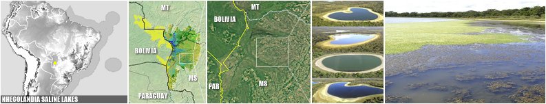
NHECOLANDIA SALINE LAKES ‣ Nhecolandia plain is the world's largest and most diversified field of tropical lakes, comprises approximately 10,000 lakes, which cover an area of 24,000 km² and vary greatly in salinity, pH, alkalinity, colour, physiography and biological activity. Among 600 of these lakes are alkaline (soda lakes), isolated from other lakes by a stripe of dry land covered by savanna vegetation, contain brackish water, pHs above 9 or 10, high alkalinity and a high density of phytoplankton, a unique landscape worldwide (Oecologia Astralis, 2020).
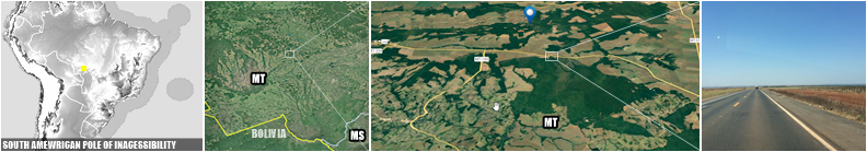
SOUTH AMERICAN POLE OF INACCESSIBILITY ‣ in South America, the continental pole of inaccessibility is in Brazil at 14.05°S 56.85°W, near Arenápolis, Mato Grosso, 1,504 km (935 mi) from the nearest coastline (D. Garcia-Castellanos & U. Lombardo, Scottish Geographical Journal, 2007), in a private area.
ACRE GEOGLYPHS ‣ Acre geoglyphs are earthen excavated structures in the ground and formed by low walls and ditches representing geometrical figures of different shapes; these enclosures were found predominantly in the eastern portion of the state of Acre, also in S Amazonas and NW Rondonia states, located in areas between streams, creek springs and wetlands, associated mostly with the Acre and Iquiri rivers; currently in the state of Acre, 306 geoglyphs type archaeological sites have been identified that are made up of 410 earthen structures (UNESCO) For a accurate map, see Balee, W., et al. (Amazonica, 2014). For a beautiful list of 187 geoglyphs listed and mapped, with photos of 76 of them, see Schaan, Ranzi & Barbosa (BOOK, 2010).
BRAZILIAN WESTERNMOST POINT ‣ a precise inspection of the 'Atas da 12ª Conferência', of the 2017 Brazil-Peru Joint Inspection Commission for Border Markers (SEE), which revised and updated the border, points out that the westernmost point of Brazil is Marco 76 (SEE), a small monument located at the exact longitude of 73º58'59''038 (despites the popular 73º59'26'' number), built in 1926 and renovated in 2007; for westermost inhabited places of country, see Mochileiros (LINK).
NEGRO/AMAZONAS RIVER CONFLUENCE ‣ the meeting of waters is the confluence between the dark Rio Negro (at near 2 km/h at a temperature of 28 °C) and the pale sandy-colored Amazonas River (4 and 6 km/h at a temperature of 22 °C), referred to as the Solimões River in Brazil upriver of this confluence; for 6 km the two rivers' waters run side by side without much mixing (Wikipedia).
RIO NEGRO FLUVIAL ISLANDS ‣ Mariuá and Anavilhanas are the two huge fluvial archipelagoes of the low Negro River in Amazonas state, that sustain the largest flooded forest systems in the world and rich fish diversity of over 1,000 spp. (E.M. Latrubesse and J.C. Stevaux, World Geomorphological Landscapes, 2015).
MOUNT/MASSIF NEBLINA ‣ is a massif (syn. Neblina Mountain Range, Sierra de La Neblina), the tallest mountain of Brazilian territory, with 2,995.3m a.s.l., in the Imeri Mountain Range, a section of the Guiana Shield on the Brazil/Venezuela border; their summit lies just within Brazilian territory, at a horizontal distance of only 687m (2,254 ft) from the Venezuelan border; it is highest mountain east of the Andes in South America, and the second outside Andes after Sierra Nevada de Santa Marta in Colombia (Wikipedia); commonly recognized as the 2nd highest peak in Brazil, here we take Pico 31 de Março as a secondary peak of Mount Neblina and not being counted here. Despite having a flat strip on the Venezuelan side, Brazil in X-Ray does not consider Mount Neblina a classic tepui.
MOUNT/TEPUI ARACÁ ‣ it's a massif of tepui type, in NE Amazonas state, being the southermost true tepui of Guiana Shield and the unique tepui enterely in Brazilian territory (Wondermondo), with a average elevation from 1,000 and 1,200m and reaches 1,750m at the summit, called peak Aparecida; this tepui comprises metasedimentary rocks represented mostly by quartzite and schist (R. G. Barbosa-Silva et al., The Botanical Review, 2020), and harbors an exceptional diversity of endemic plants, including at least one endemic genus, Yanomamua (Gentianaceae), and the only Brazilian occurrence of Viburnum (Viburnaceae, Siderasis Angiosperms/2022); for more images, see O El Dorado Aqui.
MOUNT/TABLE CABURAÍ ‣ a table-mountain located on the border between the South American countries of Brazil (Roraima state) and Guyana standing at 1,465 metres above sea level; the source of the Ailã river, located on the mountain, is the northernmost point of Brazil, in 05°16′10″ N (Wikipedia) and the 10th most austral of all those in the Northern Hemisphere (Wikipedia).
MOUNT/TEPUI RORAIMA ‣ a huge massif of tepui type, the highest of the Pakaraima Mountain Range, a unit composed of tepuis (table-top mountain); it is located at the tripoint of Venezuela, Brazil and Guyana; it is a large flat-topped mountain surrounded by cliffs 400 to 1,000 meters high; the highest point of this massif is located on the southern edge of the cliff at an altitude of 2,810m in Venezuela, and another protrusion at an altitude of 2,772m at the junction of the three countries in the north of the plateau is the highest point in Guyana (Wikipedia); it is the largest true tepui with portions in Brazilian territory.
CAPE ORANGE ‣ a cape separated from the coast of French Guiana by the estuary of the Oyapock River, located in an area of tidal marshland, being the northernmost point of the Brazilian state of Amapá and the northernmost point of the Brazilian coastline; the cape's western coastline ends at the Oyapock estuary, whose mouth marks the end of the Brazilian coast (Wikipedia). CALÇOENE MEGALITHIC OBSERVATORY ‣ Calçoene megalithic observatory ('Brazilian Stonehenge'), referred to in academic sources as AP-CA-18, is the largest known megalithic stone circle in Brazil; it contains a megalithic stone circle, consisting of 127 blocks of granite, each up to 4 meters tall, standing upright in a circle measuring over 30 meters in diameter at the bank of the Rego Grande river on a hilltop (Wikipedia); for more details, seeSaldanha & Saldanha (BOOK Chapter, 2022).
CALÇOENE RAINIEST COAST ‣ Calçoene municipality is also the rainiest point of Brazil (ANA/MIP), with a average precipitation of 4,166mm/year, documented along 30 years (Portal do Agro); punctual records can happen, with in 2000, one the precipitation reached 6,902mm (Tempo e Clima Blogspot). Oliveira, L.L. et al. (IEPA/AP, 2007), analyzing data from station 825002 in Calçoene, between 1975 and 2006, found an average of 4,238.3mm annually, above the value most commonly reported for the point.
BRAZILIAN TALLEST TREE ‣ a specimem from Dinizia excelsa Ducke (Fabaceae), measuring 88.5m tall and 9.9m around (TRT World), located on Almeirim municipality in Pará state, near border with Amapá state (G1); this tree is the is the 10th tallest in the World, 2th in the tropical region of Earth, the tallest non-Malvid angiosperm and tallest angiosperm in the New World (Siderasis).
AMAZONAS RIVER MOUTH ‣ Amazonas river has the largest fluvial descharge worldwide, with an average of about 215,000 m³/s-230,000 m³/s - approximately 6,591 km³-7,570 km³/y, greater than the next seven largest sea-flow independent rivers - Congo, Ganges, Orinoco, Yang-Tze, Rio de La Plata, Yenissei, Mississipi - combined (Wikipedia); the multiple partitions of the water flows create a network that resembles a delta of estuaries with giant islands and unstable edges, something quite unique on the planet (pers. obs.).
GREATER AMAZON REEF SYSTEM (GARS) ‣ one of the largest known reef systems in the World, with scientists estimating its length at over 1,000 km, and its area as over 9,300 km; it is composed by a mosaic of shallow patch reefs (50–70 m), mesophotic reefs (30–220 m depth), large living rhodolith beds and more complex living hard bottoms (formed mainly by fused calcareous algae) inhabited by a diverse reef biota, including threatened and commercially important species (Mahiques et al., Scientific Reports, 2019). Several maps available in Santos Filho et al. (Research Square, 2022). MARAJÓ ISLAND ‣ a large coastal island in the state of Pará state, separated from the mainland by some bays, smaller rivers and Atlantic Ocean; it is the second-largest island in South America, and the 35th largest island in the world (40,100 km², Wikipedia), or 40th (34,480 km², Almanaque Z), and largest fluvio-maritme island worldwide; the island has 16 municipalities in its extension (the largest ones marked in white on the card below) and an approximate population of 557,231 in. (Fapespa/Pará).
CARAJÁS HILLS ‣ a mountain range located in the SE Pará state, in an area of seven municipalities, characterized by the richness of mineral resources, rugged relief and the presence of plateaus of isolated ferruginous rock outcrops; being a geological and biological mosaic, this mountain range is home to two very unique habitats: the only occurrence of rocky-ferruginous grasslands (cangas) in northern Brazil (Viana et al., Rodriguésia, 2016), and a cave complex with exuberant troglobiont fauna, with about 30 spp. described and more a hundred undescribeds (G1, also Brazilian Metazoa).
AMAZON MACROTIDAL MANGROVE COAST (AMMC) - AMMC is located between Marajó Bay (PA) and São José Bay (MA) is largest continuous area of mangrove forests in the world (Tomaz et al., Revista Brasileira de Climatologia, 2019), and contains the largest and best-preserved mangrove ecosystem in Brazil, with 7,591 km² and 56.6% of all mangroves in country (W.R. Nascimento Jr. et al., Estuarine, Coastal and Shelf Science, 2012), with six species (Menezes et al., Acta Amazonica, 2008), being Avicennia possibly the tallest mangrove worldwide, with a specime measures 39 m in height, despites reports of 50 m in Colombia (Kjerfve, BOOK, pg. 31; many details from New World also found).
BRAZILIAN LARGEST-TIDE'S ZONE ‣ Maranhão Gulf has the tallest and strongest tides in Brazil, with a mean tidal range up to 6m tall in two places inside zone, in northern mangroves Bacabeira municipality, and small channels in east Alcantara and Bacurituba municialities (Czizeweski, Dissertation, 2019).
LENÇOIS SANDFIELD ‣ a large dune field of approximately 1,000 km² (2/3 of the homonymous National Park, ICMBIO) and 70km of shoreline, located in NE Maranhão state, being certainly the largest dune field in Brazil; during the rainy season, the valleys among the dunes fill with freshwater lagoons, prevented from draining due to the impermeable rock beneath (Wikipedia).
FALSE OASIS IN LENÇÓIS SANDFIELD ‣ Queimada dos Britos and Baixa Grande are two isolated patches of restinga vegetation in the complex of sands and lakes of Lençóis Maranhenses (ICMBIO; video in Youtube); in the strict sense of the word, they are not oasis, but they cause such a unique effect among Brazilian landscapes that they are considered here as a notable element, with the denomination of false oasis, cited independently for Lençóis topic.
PARNAIBA RIVER DELTA ‣ this delta, the largest true deltaic formation of Brazil with c. 2,700 km², second in South America after Orinoco one (if we disregard the mouth of the Amazonas as a delta), and 85 islands, composed dune field and mangoves enclosed by the larger Parnaíba River and the smaller Igaraçu River in eastern part, and by tidal channels associated with estuarine-lagoonal conditions in western (Geo. Mar. Lett., 2014).
GIANT CASHEW TREE ‣ it is an individual of Anacardium occidentale L. born in Cajueiro da Praia-PI, with 8,834 m² of coverage, being considered the most expanded tree in Brazil (Cidade Verde); rivals a cashew tree from Pirangi-RN, which has 8,500m² (Agro News); for genetic data on the plant, see Do Amaral F.P.M. et al. (Genetics and Molecular Research, 2017).
ROCAS ATOLL ‣ is a small atoll off northern Brail, only in the South Atlantic Ocean and around South America, at Rio Grande do Norte state jurisdiction, and located approximately 260 km northeast of Natal and 145 km west of the Fernando de Noronha archipelago; the atoll is of volcanic origin and coralline formation, has two small islands and none permanent population (Wikipedia).
FERNANDO DE NORONHA ARCHIPELAGO ‣ an archipelago extremely popular in the Atlantic Ocean, part of the State of Pernambuco, Brazil, and located 354 km off the Brazilian coast, consisting of 21 islands and islets, extending over an area of 26 km²; only the eponymous main island is inhabited; it has an area of 18.4 km² and a population estimated at 3,101 in 2020 (Wikipedia), whose highest point reaches 323m; it is the most remote permanently inhabited point in Brazil.
ST. PETER AND ST. PAUL ROCKS ‣ a group of 15 small islets and rocks with 0.17 km² of area, located in the central equatorial Atlantic Ocean in the Intertropical Convergence Zone, a region of the Atlantic characterized by low average winds punctuated with local thunderstorms; its lies approximately 940 km from the nearest point of mainland South America (town of Touros); 625 km northeast of the archipelago of Fernando de Noronha and 1,824 km from the west coast of Africa; this grouping is the sole location in the Atlantic Ocean where the abyssal mantle is exposed above sea level (Wikipedia).
BRAZILIAN MAINLAND EASTERMOST POINT ‣ Cape Seixas, also known as Cape Branco, is a cape on the Atlantic coast of Paraíba state, E Brazil, that forms the easternmost point of the Brazil and American mainlands, roughly 8 km (5 mi) southeast of João Pessoa, the state capital (Wikipedia), and the 14th easternmost point of all the countries that have it west of Greenwich (Wikipedia).
INGÁ ROCK ‣ an archaeological monument consisting of a rocky terrain that has rock inscriptions carved into the rock, located in municipality of Ingá, Paraíba state; is a gneiss formation covering c. 250 m², having in its main set a vertical wall 50 meters long by 3 meters high, on which several figures are carved, which suggest the representation of animals, fruits, humans and constellations such as Orion (Wikipedia).
BRAZILIAN DRIEST PLACE ‣ Cabaceiras municipality from Paraíba state is the most dry place in Brazil, with an average of 336.6 mm with 86 years of observations; during the 86 years studied the total annual extreme rainfall were recorded in the year 1964 in which it rained 775.5 mm and 1952 when the annual total recorded was 23.8 mm (Breckam et al., Rev. Educ. Agrícola Superior, 2013). SERRA DA CAPIVARA ARCHEOLOGICAL PARK ‣ a flat-mountain cliffed area with the possibly largest and the oldest concentration of prehistoric sites in the Americas (archaeological and paleontological, despites a huge list of controversial notes; see Current World Archaeology, Issue 37), with many prehistoric arts, with about 1,300 sites, of this 900 with paintings; for many details, see Lourdeal (Bol. Mus. Par. Emilio Goeldi, 2019).
MIDDLE SÃO FRANCISCO PALEODUNES ‣ a complex of two inative 'fossil' sand fields in left side of Rio São Francscio in NW Bahia state, the largest of Brazil in this type of dunes: a western bank field, with c. 88 km², and eastern bank with c. 200 km², composed by 'fossil' dunes with heights between 5-10 m to 50-60 m, with an average between 15 and 25 m, and horizontal extent most commonly between 1-3 km, but some parabolic dunes can be over 10 km (SIGEP/CPRM).
TOCA DA BOA VISTA CAVE ‣ composed by Proterozoic dolomites, the largest cave known in Brazil and the 2th southern hemisphere (after Bullita Cave in Australia) with 114 km of mapped galleries, being the 21th in world (Wikipedia), located in the north of Bahia in Campo Formoso municipality (SIGEP/CPRM) - exact location available in Linkedin (SEE).
BRAZILIAN DESERT PLACE ‣ in 2023, research by Cemaden and Inpe identified in the historical series the first region with a truly arid climate in Brazil (CEMADEN), a area of 5,763 km² and is located in the center-north of Bahia and covers the entire area of the cities of Abaré, Chorrochó and Macururé, in addition of area of Curaçá, Juazeiro and Rodelas, municipalities in Bahia that border the Pernambuco hinterland, with an aridity index of less than 0.2 (G1).

AGUAS CLARAS CAVE SYSTEM (ACCS) ‣ located on Carinhanha municipality (BA), ACCS, with approximately 24 km, composed of four limestone caves (Marconi Souza-Silva et al., Biodiversity and Conservation, 2021), is the richest hotspot of subterranean biodiversity in South America, with 41 species that are restricted to caves, with distribution across Hexapoda (14), Arachnida (10), Isopoda (6), Diplopoda (7), Gastropoda (2), Turbellaria (1), and Actinopterigii (1), ahead Toca do Gonçalo (also in Bahia) and Areias (S São Paulo state) cave systems, the unique other two hotspots in South America (R.L.Ferreira & Marconi Souza-Silva, Diversity, 2023).
ABROLHOS BANK CORAL REEF ‣ the most extensive area of coral reefs in Brazil and of all the South Atlantic Ocean, however with less than 1% of the reef ecosystems worldwide, in an area of approximately 6,000 km² in the northern part of the Abrolhos Bank; for more details, see Bate Papo com Netuno.
COSTA DOURADA CLIFFS ‣ in some points of the coast there are cliffs, a good part of sandy geology. In Brazil these forms occurs in Beberibe, Aracati, Icapuí (CE), Touros, Tibau do Sul (RN), João Pessoa (PB), Roteiro (AL), Mucuri (BA), and Torres (RS), in independent systems (Saiba Mais, 2021). The site Almanaque Z considers a stretch of Costa Dourada Cliffs as the longest contunuous in Brazil (SEE), with 2,7 km lenght.
BRAZILIAN ATLANTIC DEEPEST POINT ‣ the lowest point of the Brazilian EEZ and, therefore, of the entire national territory, can be found by accessing the Ocean Basemap (SEE), activating 'layers', selecting ArcGIS Online mode, searching for 'Brasil ZEE', and activating the correct layer for a visual search. Then, the Bathymetric Data Viewer (SEE) helps to obtain the exact point. The exact point is located at the approximate coordinates of 25°43'12" W 19°25'40.8" S, reaching a depth of -6182m, and does not have an official name, being 348 km from Martim Vaz island and 1,430 km from the mainland, at the latitude of Bahia.
ROCK PEDRA RISCADA ‣ largest monolith in Brazil and also the largest rocky wall in Brazil, with 950m of extension between base and summit, located in E Minas Gerais state and with a summit reaching 1,230m above sea level; widely used for climbing, it has 17 routes and variants to reach its immense top (Escaladas, also Eliseu Frechou); sometimes assinated as the largest monolith of the world (CBG/2017).
GARANDELA GIANT PALEOBURROW ‣ c. 2,000 paleoburrows have been found in South America, mostly in the southern Brazil, Uruguay and Argentina (The World), with a record in Rondônia state (G1); Garandela Giant Paleoburrow, in Caeté municipality, SE Minas Gerais state, is possibly the largest worldwide (Ruchkys et al., Caderno de Geografia, 2014), with 340m in lenght; for details about paleoburrows, see Frank et al. (SBP Monographies, 2012).
CENTENARIO CAVE ‣ Centenario Cave, located on Mariana municipality in Minas Gerais state, is the most deep cave in Brazil, with depth between 481 (Bambuí/GPME) and 484m (Bambuí Speleo), being also the deepest in the world in quartzite; in cards, profile plans of the cave [3] and external view of its entrance, which is vertical [4]; more data in Geosítios/Gruta do Centenário.

MASSIF CAPARAÓ ‣ syn. Massif Caparaó and Caparaó Mountain Range, is the second highest mountain in Brazil (2,896.2m), situated on the border of Espírito Santo and Minas Gerais states, being the highest point in both states and historically considered the highest mountain in Brazil until 1965, when Mount Neblina, next to the Venezuelan border, were explored, measured, and both found to be higher; this mountains is also remarkable for being the Brazilian mountain with the greatest topographic isolation: 2,344 km; in the Americas, only Aconcagua, Denali, Pico de Orizaba and Mount Whitney are more topographically isolated than Pico da Bandeira, and in the entire world, there are only 20 more isolated mountains (Wikipedia).
PALMAS LAKE ‣ this lake, located in Linhares municipality Espírito Santo state, has maximum depth of 50.7m, a volume of 0.22 km³ and a mean depth of 21.4 m, being the deepest natural lake in Brazil (Barroso et al., Plos One, 2014).
JUPARANÃ LAKE ‣ also in Espírito Santo state, this lake is the largest (62.58 km², Amorim Gonçalves, Dissertation, 2015) and most volumous freshwater lake enterely in Brazil (0.5281 km³, estimative of Almanaque Z, SEE), and second of both features in country, in both cases after Mirim Lake (see below) which reaches into Uruguay.
BRAZILIAN KELP FOREST ‣ Brazil has the unique kelp 'forests' of tropical Atlantic Ocean in Americas (Wernberg et al., World Seas, 2019; also Jayathilake et al., Biological Conservation, 2020), composed by endemic Laminaria abyssalis A.B.Joly & E.C.Oliveira, a deep tropical species prostrate growing up to 5-6m long, from N Espírito Santo coast up to C Rio de Janeiro states, in a small atrea of 33,000 km² (details in Ictiolab/2021); for others images, see Fernandes et al. (BOOK, 2021).
TRINDADE AND MARTIM VAZ ISLANDS ‣ Trindade and Martim Vaz is an archipelago with 10.4 km² located in the South Atlantic Ocean about 1,100 kilometres east of the coast of the Brazilian state of Espírito Santo and the most disconex portion of territory, of which it forms a part; there are six islands and numerous rockes, being Trindade mountainous, desiccated volcanic island with numerous phonolitic lava domes and steep-sided volcanic plugs reaching up to 620 m; South Island near Martim Vaz is the easternmost point of Brazil (28°51′00″W); there is a small settlement in the north on the shore of a cove called Enseada dos Portugueses, supporting a garrison of the Brazilian Navy, 32 strong (Wikipedia). CABO FRIO UPWELLING ‣ upwelling is a phenomenon in the oceans where cold deep waters rise to the surface of the sea, in complex systems involving the Coriolis effect, wind systems, and the rotation of the Earth. The largest systems are located off the western coasts of continents, although they occur at various points (SEE). Coastal upwelling occurs on the Brazilian shelf in three different regions: off southern Bahia (15° S–19° S), off Cabo Frio (20° S–24° S), and off Cabo de Santa Marta (Kaempf & Chapman, BOOK, 2016). The most prominent of these systems is the Cabo Frio Upwelling System (CFUS). The spatial extension of the upwelling and the temperature anomalies associated with it are about 500 km and -4.5°C at 23°S, respectively (Santos, F.H. et al., SBSR, 2015). This phenomenon makes the waters significantly colder compared to the ambient temperature, especially between August and September, while also providing a high density of nutrients (Olhar Oceânico, 2023).

BRAZILIAN ASPHALT SEEP ‣ Brazil has only three chemosynthetic ecosystems at their sea, one is Brazilian aspahlt seeps, escarpment of asphalt on the seafloor relief, known only in 2013, the only representing only the third discovery of this type of seep worldwide, following those in the Gulf of Mexico and off Angola (Fukujima et al., DSRP II, 2017); Brazilian souces has a total length of approximately 5.6 km (Jiang et al., Scientific Reports, 2018).
SALT LAKE ‣ this lake in northern coast of Rio de Janeiro state contains the unique ocurrence of recent columnar carbonate stromatolites of whole of Brazil and probably of the South America (SIGEP); for more details, see Geoparques Costões e Lagunas (SEE) and Ambiente Cult (SEE, 2009).
ARARUAMA LAKE ‣ Araruama Lake, located in Rio de Janiero state, is the largest body of permanent hypersaline water in the world, with 220 km², surpassing other prominent hypersaline water bodies such as the Great Salt Lake (United States), Lake Coorong (Australia), Lake Enriquillo (Dominican Republic) and the Lagoon Ojo de Liebre in Mexico (Wikipedia), the second largest saltwater lake in Brazil after Mangueira Lake.
NEBLINA WATERFALL ‣ Neblina Waterfall is the tallest waterfall in Brazil, standing at 450 meters high. It is located in the Serra dos Órgãos National Park, in Guapimirim municipality, Rio de Janeiro (cachoeirasgigantes).
GÁVEA ROCK ‣ a monolithic rock in Tijuca Forest, Rio de Janeiro, Brazil, composed of granite and gneiss, its elevation is 844m, being the world's largest monolith on the coastline (Wikipedia).
CASA DA PEDRA CAVE ‣ a cave located inside a foresty mountains in the south of the state of São Paulo, in the Atlantic Forest region, being the largest cave entrance in the world, recognized by the Guinness Book, with an incredible 215m high (Petar).
GUARANI AQUIFER ‣ often mistaken as 'an underground lake or river', aquifer are like an underground sponge - buried layers of sand and gravel saturated with water; Guarani Aquifer System represents the second largest aquifer in the world (after Great Artesian Basin, in Australia, SEE) and the largest in Brazil, occupying 950,000 km² within the Paraná sedimentary basin at 8 states, reaching also in othre three countries: Argentina, Paraguay, and Uruguay; 90 million people are directly or indirectly benefitting from the GAS exploitation (Teramoto, Gonçalves & Chang, Journal of Hydrology: Regional Studies, 2022).
IGUAZU FALLS ‣ extremelly famous, are waterfalls of the Iguazu River on the border of the Argentine province of Misiones and the Brazilian state of Paraná; together, they make the eight volumous waterfall system in the world (ignoring Paulo Afonso falls, which has an artificial flow resulting from damming) and largest of Brazil, 35 and 40m in height and with an average rate of 1,746 m³/s; its maximum recorded flow was 45,700 m³/s on 9 June 2014 (Wikipedia).
PARANÁ LAVA TUBES ‣ in Brazil, only four lava tubes are known: Casa de Pedra and Perau Branco (both in the municipality of Palmital), Dal Pae (municipality of Marquinho), and Pinhão (municipality of Pinhão), all located in the state of Paraná (SINAGEO/2016). For details on the first two, see Waichel, B.L. et al (Journal of South American Earth Sciences, 2013).
YACUMAN FALLS ‣ this falls are an important set of waterfalls between Derrubadas, in Rio Grande do Sul state, and El Soberbio, in the Argentine province of Misiones; it is the largest longitudinal waterfall in the world, measuring 1,800m in length and reaching a height of up to 20m (Wikipedia).
SANTA CATARINA ISLAND ‣ this island in Santa Catarina state, belonging to the municipality of Florianópolis is, in the concept proposed by Almanaque Z (
SEE), the
largest fully isolated island in Brazil, sufficiently distinct from the mainland in its contour, with 424.4 km².
ISLAND OF SEA LIONS ‣ a small volcanic islet, the smallest conservation unit in Brazil, the only maritime island on the coast of Rio Grande do Sul, opposite the beaches of Torres, about 1.8 km from the shore, has an area of approximately 2 ha and the average depth of the place is 15 to 20m; the site is one of two unique refuge of pinippedes in Brazil, for seals (Arctocephalus australis, 136 in 2019) and sea lions (Otaria flavescens, 156 in 2014), which use the place on their migratory routes (Torres Website).
TORRES CLIFFS ‣ the cliffs of Torres, north coast of Rio Grande do Sul, are the highest in Brazil, reaching 48m in height and are of basaltic formation (Torres Webpage).
ITAIMBEZINHO CANYON ‣ the Itaimbeznho canyon is the most charismatic canyon in Brazil, despite being neither the deepest (after Fortaleza canyon, Viagens e Caminhos/2021) nor the longest (after Guaterlá canyon). It is 5.8 km long, 720 meters deep and 200 meters wide. The upper part of the canyon is in the municipality of Cambará do Sul, in Rio Grande do Sul and the lower part of the crater is in the municipality of Praia Grande, in Santa Catarina (Revista Sabores do Sul).
LAGUNA OF PATOS ‣ is the largest coastal lagoon in South America and Brazil, located in southern region, covering an area of 10,100 km², separated from the Atlantic Ocean by a sandbar about 5 miles, at sea level and its waters are affected by the tides, normally they are brackish only a short distance above the Rio Grande outlet, but this can vary a lot; in droughts and favorable winds, sea water can be carried up to almost the entire lagoon (Wikipedia).
CASSINO BEACH ‣ located in southermost portion of Brazilian coast in Rio Grande do Sul state, with c. 240 km, it´s the longest beach worldwide in several sources, e.g. Statista (SEE, data in miles) and Travel2next (SEE).
COLD SEEP FIELDS OFF RIO GRANDE DO SUL ‣ Brazil has only three chemosynthetic ecosystems at their sea, one is a gas hydrate field, the unique in western South Atlantic, in Rio Grande Cone Gas Hydrate Province, in 500-600m deep, and c. 1,300 km off Rio Grande do Sul state (SEE MORE).
MIRIM LAKE ‣ Mirim Lake is the largest freshwater lake in Brazilian territory, with average are c. 3,749 km² (3,381 - 3,863 km²), c. 2/3 in Brazil and 1/3 in Uruguay (Wikipedia); has an average depth of 4.5 m (Munar et al., SBRH, 2017; maximous of 16m), accumulating, based on these numbers, a average of volume of 16.87 km³ (IPH, 1998), the largest for a Brazilian lake.
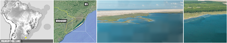
MANGUEIRA LAKE ‣ located in SE Rio Grande do Sul state, it's a shallow, closed system with no tidal effect, Mangueira Lake has a length of 96 km and a width of 7.6 km at its widest point, with an average depth of 2.5 m. It has no tributaries and no surface connection to the Atlantic Ocean (Scielo Brazil). With 0.7 km³ of volumen, it's the largest saltwater lake for Brazil (Artioli et al., Iheringia, 2009). In Brazil, Mangueira Lake is the only natural site of blue-green algae Spirulina, which can also be found in other countries such as Spain (Lagoa de Santa Olalla), Mexico (Lake Texcoco), Cameroon, Chad, Niger, and Nigeria (Lake Chad), among others (Gente de Opinião).
ARROYO CHUY ‣ is a short stream on the Brazilian–Uruguayan border, known throughout Brazil and generally mentioned as the country's southernmost point, located on a bend of the stream approximately 2.7 km upstream from its mouth, near the twin coastal villages of Barra do Chuí (Brazil) and Barra del Chuy (Uruguay), at 33°45′03.49″S; more than that, the relevance of Arroyo Chuí is also by the mouth, which is at the same time southernmost and westernmost point of the Brazilian coast, as well as both the northernmost and easternmost point of the Uruguayan coast; it also marks the southern end of Cassino Beach, the world's longest uninterrupted beach (Wikipedia).