LOCATION ‣ present-day Brazil was part of the ancient continent Pangea, a term coined by Alfred Wegener in his 1920 book - including, most visible evidence of this split is in the similar shape of the coastlines of modern-day Brazil and West Africa. According to the probable distribution of the supercontinent, present-day Brazil had land connections with its present-day neighbors and with several West African countries, from Sierra Leone to Namibia. From 550 to 180 M years ago, Brazil was part of Gondwanaland, the southern continent, maintaining its same neighborhood in Pangaea. This continent follows a set of high-intensity events of the Neoproterozoic period, called the Brasiliana Orogeny. A high interest map for similar geology of northern South America and W Africa is available in Steel Club (SEE).
ANTIPODES ‣ most of the World has no antipodes on land. The exception is for South America, East and Southeast Asia, Antarctica and the Arctic region. Much of the Canadian islands, Greenland and a fraction of Siberia are antipodes of Antarctica, including the Antarctic Peninsula. A very significant portion from China is antipodal to Argentina and Chile, Peru antipodal to Indochina, Ecuador antipodal to peninsular Malaysia and Colombia antipodal to Sumatra. Sulawesi is antipode of Guyana and Pará state in N Brazil, while Borneo and the Philippines are antipodes of Brazil, in the states of Mato Grosso, Pará, Roraima and Amazonas.
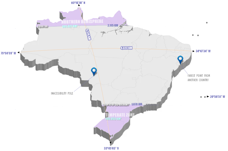
EXTREMES AND COORDINATES OF BRAZIL ‣ situated entirely in the Western Hemisphere, the three latitudinal extremes (west, mainland east, over east) of the country are west Greenwich. Crossed by the Equator and the Tropic of Capricorn, the northern end of the country is in the Northern Hemisphere, and the southern end is in the southern temperate region. Brazil is the longest country in the world, spanning 4,395 km from north to south, and the only country in the world that has the equator and a tropical line (Tropic of Capricorn) running through it. For many curiosities for Brazilian territory, see Lista de Extremos do Brasil (Wikipedia).
ZONES
Northern Hemisphere cover in Brazil 601,427 km² (7,062 % of total area), in approximate values in manual measurement of Brazil in X-Ray in Google Earth polygon tool, are in Amazonas (140,600 km² in western portion, 3,960 km² in eastern portion), Roraima (201,347 km²), Pará (128,234 km²) and Amapá (127,286 km²). With same metodology, temperate zone cover a very similar area, 600,935 km² (7,056% of country area) in partial São Paulo (48,319 km²), Mato Grosso do Sul (8,250 km²), and Paraná (167,272 km²), and over Santa Catarina (95,346 km²) and Rio Grande do Sul states (281,748 km²).
EXTREMES
The distances of the latitudinal and longitudinal extremes are almost equivalent, with a difference of only 53 km, less than 2% of both (4,379 km N/S, 4,323 km E/W). Interestingly, the continental E and W extremes are almost at the same latitude (0º22'48'' difference), which makes the segment that connects them almost coincident with the largest parallel in the national territory (approx. 7º21' S) and also the longest 'straight' line inside Brazilian territory. The longest meridian in the national territory (approx. 53º29' W) is approximately 3,832 km long and is quite distinct from the segment that joins the N and S extremes.
N: Monte Caburaí, Roraima (RR, 05°16′10″ N; for details inside a expedition, see Amazonas Abenteuer).
The extreme north of Brazil is the 10th most southern of all those in the Northern Hemisphere (SEE).
E (continental): Ponta do Seixas, Paraíba (PB, 34°47′34″ W).
Easternmost continental part of Brazil is the 14th easternmost of all the countries that have it west of Greenwich (SEE), and the easternmost of the Americas.
E (over): Ilha do Sul, Ilhas de Martim Vaz, Espírito Santo (ES, 28°50′51″ W).
S: Arroio Chuí, Rio Grande do Sul (RS, 33°45′03″ S).
The extreme south of Brazil is the 7th most southern for a sovereign country (SEE).
W: Serra do Divisor, Acre (AC, 73°58′59″ W).
Brazilian extreme west is the 23rd most westerly of all (SEE).
POLE OF INACESSIBILITY
In South America, the continental Pole of Inaccessibility is in Brazil at 14.05°S 56.85°W, near Arenápolis, Mato Grosso, 1,504 km (935 mi) from the nearest coastline (Wikipedia); for technical details, see Castellanos & lombardo (Scottish Geographical Journal, 2007).
 BRAZILIAN EXTREMES, LENGHTS OF IMPORTANT LINES, ZONES, AND OTHER REMARKABLE POINTS
DISTANCES ‣ northernmost point of Brazil is closer to Canada, at the height of Nova Scotia, than to the southernmost points of Brazil (4,262 km ✕ 4,379 km). Rio Grande do Norte is closer to Africa, at the height of Guinea-Bissau (2,768 km), than to cities like Curitiba or Manaus.
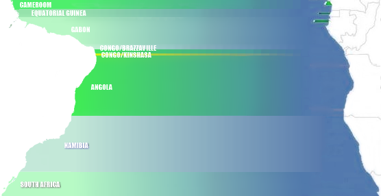
LINES IN SEA ‣ from the Brazilian coast, going east, there is the African coast, with Amapá facing Cameroon and Equatorial Guinea, from Amapá to Rio Grande do Norte all facing Gabon (except a portion defront Congo/Brazzaville), a small fraction of Rio Grande do Norte facing Congo/Kinshasa, Rio Grande do Norte to Bahia all facing Angola, from Bahia to Santa Catarina facing Namibia, and from there to Chuí, facing South Africa.
ATLANTIC BRAZIL ‣ The Brazilian coastline extends for 7,491 km, making it the 15th longest national coastline in the world (Wikipedia, SEE). Approximately 8.15% of it lies in the Northern Hemisphere, while the remaining 91.85% stretches across the Southern Hemisphere, spanning 17 states. The entire coast borders the Atlantic Ocean. The coastal region features a diverse array of geographical formations, including islands, bays, tropical beaches interspersed with mangroves, lagoons, tidal flats, dunes, and extensive coral reefs. Brazil is home to 2,095 beaches, renowned worldwide for their beauty and attracting a large number of tourists. For the most comprehensive reference on Brazil’s coastal zones, consult the Atlas Geográfico das Zonas Costeiras e Oceânicas do Brasil (IBGE, 2011, SEE).
A recent global remote sensing analysis estimated that Brazil has 5,389 km² of tidal flats, ranking it as the 7th country with the largest tidal flat areas (Murray et al., Nature, 2018).
Brazilian Maritime Territory refers to Brazil’s Exclusive Economic Zone (EEZ), an offshore area covering 3.6 M km² along the Brazilian coast, making it the 11th largest in the world. This vast region is rich in marine biodiversity and energy resources, with a size comparable to that of the Amazon. Brazil has submitted a claim to the United Nations Commission on the Limits of the Continental Shelf (CLCS) to expand its EEZ to 4.4 million km². The proposal seeks to extend Brazil’s continental shelf by 900,000 km², granting the country rights to explore and exploit marine soil and subsoil resources. If approved, the extension will create a more contiguous maritime area, encompassing Brazilian archipelagos in the South Atlantic. The Northeast region contains the largest portion of Brazil’s EEZ due to several widely spaced islands forming a continuous marine zone. However, Trindade Island lies too far from the coast to be included in a similar configuration (Wikipedia).
The lowest point of the Brazilian EEZ and, therefore, of the entire national territory, can be found by accessing the Ocean Basemap (SEE), activating 'layers', selecting ArcGIS Online mode, searching for 'Brasil ZEE', and activating the correct layer for a visual search. Then, the Bathymetric Data Viewer (SEE) helps to obtain the exact point. The exact point is located at the approximate coordinates of 25°43'12" W 19°25'40.8" S, reaching a depth of -6182m, and does not have an official name, being 348 km from Martim Vaz island and 1,430 km from the mainland, at the latitude of Bahia.

|
|
BRAZILIAN COASTLINE, LENGHT BY STATE, EEZ, OCEANIC ISLANDS, AND TABLES FOR LARGESTS EEZ'S AND COASTLINES WORLDWIDE |
Brazil has five island groups comprising 58 islands across four sets of oceanic islands, all located more than 100 km from the coast (Serafini, França & Andriguetto-Filho, Journal of Integrated Coastal Zone Management, 2010). Fernando de Noronha (PE, 352 km off Rio Grande do Norte, 21 islands and islets) is inhabited and serves as a tourist destination, albeit with some environmental restrictions. Saint Peter and Saint Paul Archipelago (PE,
SALINITY AROUND SOUTH AMERICA
940 km off Rio Grande do Norte, 15 islets and rocky outcrops, SEE), Rocas Atoll (RN, 231 km from the mainland, two islands/islets, SEE) and Trindade Island and Martim Vaz Archipelago (ES, liyng 1,090 km off Espírito Santo, five islands and multiple rocks, SEE in Trindade, while Martim Vaz is 1,142 km offshore, consisting of one main island and several smaller rocks). Together, these island groups cover a total area of 37.3 km² and had 3,141 inhabitants as of 2020 (SEE).
Regarding biodiversity on these islands, Rocas Atoll hosts 18 species of insects and 7 species of arachnids (Almeida C.E. et al., Rev. Bras. Biol., 2000). Fernando de Noronha is home to three endemic land snail species (Salvador et al., Tentacle, 2022) and 453 insect species across 21 orders, primarily Diptera and Coleoptera (Rafael et al., Rev. Bras. Entomol., 2020). The Noronha worm lizard is a reptile closely related to Caribbean species of the same genus (Graboski et al., Mol. Phyl. and Evol., 2019). For data on Collembola in Brazilian islands, Lima et al. (Insects, 2021) provide information on Poduromorpha, while Lima et al. (Diversity, 2021) focus on Entomobryomorpha. In terms of bryophytes, Fernando de Noronha has 31 species across 14 genera and 14 families (Fieldguides, 2021), while Trindade hosts 38 species, including 20 liverworts, 17 mosses, and one hornwort (Fieldguides, 2022).
Knowledge of Brazil's deep oceans has seen a relative increase in recent years, largely as a result of a partnership with Japanese institutions; for excellent prospecting work on the southeastern coast larf, see several works publicied in 2020 at Deep Sea Research (Editorial, 2017), inc. deep sea works in São Paulo ridge (SEE), Rio Grande Rise (benthic megafauna/SEE and benthopelagic megafauna/SEE), (SEE). Other deep sea works in submersile vehicles includes discoveries of sponges in Amazonas river mouth (Moser et al., Zootaxa, 2022; see also Zenodo). The most complete reference for Brazilian deep sea biodiversity, see the homonymous book, by Sumida et al. (Springer, 2020).
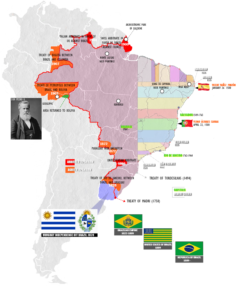
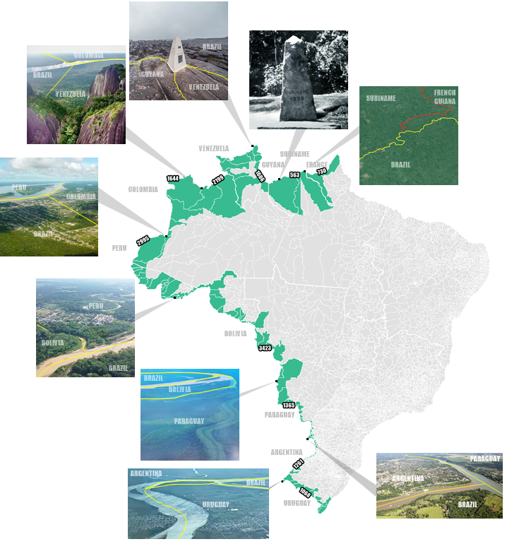
BRAZILIAN BORDERS ‣ Brazil has 14,691 km of borders, making it the third longest in the world. It shares land borders with 10 countries, ranking 11th globally in land border length and first in the New World. In terms of the number of neighboring countries, Brazil ranks 4th worldwide (or 3rd if considering only Metropolitan France) (Wikipedia, SEE). Administratively, Brazil’s borders encompass 121 border municipalities across 11 states, covering approximately 1.4 M km² and home to around 730 K inhabitants. The country also has nine international tripoints: six located in rivers, one at a mountain summit, and the two northernmost points deep within the Amazon. Brazil’s border with Bolivia stretches 3,403 km, making it the 8th longest international border in the world (Statista). For details on specific tripoints, see BR/GU/VZ (GOV.BR), BR/VZ/CL (X), and BR/BL/PAR (Amboro Tours). A comprehensive list of public documents—including treaties, reports, collections, maps, and links—related to Brazil’s borders is available at PCDL (MRE).
 BRAZILIAN BORDERS, LENGHT BY COUNTRY, MUNICIPALITIES IN LINE AND TRIPOINTS
BRAZILIAN RELIEF ‣ contrasting to the Andes, which rose to elevations of nearly 7,000 m in a relatively recent epoch and inverted the Amazonia direction of flow from westward to eastward, Brazil's geological formation is very old. Precambrian crystalline shields cover approx 2/5 of the territory, especially its central area. Brazil no has surface below sea level.
ALTITUDES
Approximately 0.5% of Brazil's territory lies above 1,200 m in elevation. Central Highlands encompass a vast plateau (Planalto Central), characterized by uneven terrain with an average elevation of 1,000 m. The rest of the country consists primarily of sedimentary basins, the largest of which is drained by the Amazon River and its tributaries. In total, 41% of Brazil’s land area sits at an elevation of less than 200 m (Wikipedia).
 MEAN ALTITUDE BY MUNICIPALITY IN BRAZIL, HIGHLIGHTING CAMPOS DO JORDÃO (SEE), THE HIGHEST CITY IN COUNTRY
Brazil has an average altitude of 325 m above sea level. Almost two-thirds of Brazilian municipalities are above this average. In total, 176 Brazilian municipalities, including Brasília (DF), have average altitudes exceeding 1,000 meters. These municipalities have colder climates than nearby locations in the same state (Nexo Jornal, 2024). Campos do Jordão, in Mantiqueira Highs, in the highest city in Brazil, with 1,628m a.s.l. (G1).
MOUNTAINS
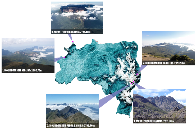
Eastern Brazil harbours the second most extensive South American network of mountain ranges, surpassed only by the Andes. The Mantiqueira Range and the Espinhaço Range (hereafter Mantiqueira and Espinhaço) are two nearly connected main orogenic belts of southeastern Brazil. Together, these highlands are distributed along a broad latitudinal range (10°S–24°S), extending approximately 1600 km from north to south, reaching up to 2890 m high. Mantiqueira Range is divided into two sections: southern Mantiqueira extends from E São Paulo state along the southern border of Minas Gerais state, whereas the northern section is on the border of the states of Minas Gerais and Espírito Santo. Espinhaço is also divided into two main sections: the Septentrional Espinhaço in Bahia State and the Meridional Espinhaço, mainly in Minas Gerais State, with the Quadrilátero Ferrífero (hereafter Quadrilátero) region representing its southernmost mountain formation. The Mantiqueira is fully embedded within the Atlantic Forest domain (AF), while the Meridional Espinhaço is in a transitional zone between the AF to the east and the Cerrado domain to the west, both global biodiversity hotspots. Septentrional Espinhaço, despite being influenced by the AF and Cerrado, lies within the Caatinga domain (Brunes, T.O. et al., Systematics and Biodiversity, 2023).
 BRAZILIAN FIVE HIGHEST MOUNTAINS
Brazil in X-RAY considers that the highest mountains in Brazil are determined by massifs, which rules out the false multiplication of peaks. Based on this understanding, we do not consider Pico 31 de Março as distinct from Pico da Neblina, neither Pico do Calçado and Pico do Cristal as distinct from Pico da Bandeira. In this way, the five highest mountains in Brazil (all over 2,730m) are the ones that follow below. Brazil highest point (Mount Neblina, 2,992m) is only the 71th highest in the world (SEE), smaller than the respective for all neighbours except Guianas, Paraguay and Uruguay, evidencing the low altitude of the national territory - by the way, Brazil has only 320m of average altitude, being in position 118 in the ranking of highest countries (SEE). Mount Bandeira (2,892m), the second highest mountain in country, is remarkable for being the Brazilian mountain with the greatest topographic isolation: 2,344 km (SEE). In Americas, only Aconcagua, Mount McKinley, Pico de Orizaba and Mount Whitney are more topographically isolated than Pico da Bandeira, and in the entire world, there are only 20 more isolated mountains. A list of the 30 tallest mountains in Brazil is available in Trilhas Conectam (SEE).
The mentioned altitude of Mount/Tepui Roraima below is not that of the top of the mountain, but that of the geodesic mark at the triple point of the borders of Brazil, Venezuela and Guyana; this landmark is the highest point of the mountain that is at least partially in Brazilian territory. The highest point of Mount Roraima as a whole is located in entirely Venezuelan territory (Wikipedia). To follow a beautiful expedition to the top of Mount Neblina, see SPOT Brasil (YT/2018).
BRAZILIAN CAVES ‣ caves are a striking element of the planet's landscapes, and they are as diverse as they are fascinating, occurring both on land and underwater, in various latitudes and lithologies, and varing in size, inclinations and many other elements.
INLAND CAVES
Brazil has 20,147 caves, being, for example, 8,057 in the São Francisco River basin, 9,225 in the Cerrado, 8,854 in Minas Gerais (ICMBio, 2019 | CNC/2022. The two largest Brazilian caves in horizontal projection are Toca da Boa Vista (114 km) and Toca da Barriguda (35 km), both in Campo Formoso, Bahia. In depth are Centenário Cave (484 m) and the Bocaina Cave (404 m), both in Mariana, Minas Gerais (Grupo Bambuí). Riacho Subterrâneo cave in Itu, São Paulo state, is the largest cave in igneous rock of the Southern Hemisphere with approximately 1,500m of devel-opment in mapped passageways (Bichuette et al, Neotropical Biology and Conservation, 2017).
Toca da Boa Vista is the 22th largest cave of World and the second in southern Hemisphere after Builita Cave in Australia (Wikipedia).
A cenote is a natural pit, or sinkhole, resulting when a collapse of limestone bedrock exposes groundwater. The term originated on the Yucatán Peninsula of Mexico, where the ancient Maya commonly used cenotes for water supplies, and occasionally for sacrificial offerings. The term cenote, originally applying only to the features in Yucatán, has since been applied by researchers to similar karst features in other places such as in Cuba, Australia, Europe, Brazil (National Geographic Brazil) and U.S.A. (Wikipedia).
SUBMARINE CAVES
Only five localities in Brazil are known to have submarine caves, and all of them are still poorly studied. Off Rio de Janeiro city, there is a semi-submerged cave called 'Buff', located on Filhote da Redonda Island. Although underwater photographs show a rich benthic fauna inside, there are no published descriptions of its benthic communities so far. In Arraial do Cabo, a semi-submerged cave named 'Gruta Azul' is a famous touristic attraction. Fifteen sponge species were reported from this cave, mostly of the class Calcarea and a few Demospongiae. There are other submarine caves in Arraial do Cabo, such as 'Gruta da Camarinha' and 'Buraco dos Meros', but their benthic communities remain unexplored. On the Abrolhos Archipelago, there is a large submerged cave on Siriba Island, from which a single sponge species has been reported so far. Furthermore, on the Rocas Atoll, there are two large tunnels (named 'Fendas 1 and 2') colonized by a rich sponge community, with 17 sponge species reported to date. Finally, on the Fernando de Noronha Archipelago there are many submarine caves and tunnels, which are still poorly known (Guilherme Muricy et al, Journal Marine Science Engineering, 2024).
LAVA TUBES
Volcanic caves formed by the emptying of lava tubes represent the second most common type of cave on Earth. They are widely referenced in specialized literature, particularly in association with recent volcanism. The most classic examples include the lava tubes of Hawaii, the Galápagos, and the Canary Islands. Although neither the Wikipedia list (SEE) nor Ziggy Sawlowicz (Annales Societatis Geologorum Poloniae, 2020) mention their occurrence in Brazil, four lava tubes are known in the country: Casa de Pedra and Perau Branco (both in the municipality of Palmital), Dal Pae (municipality of Marquinho), and Pinhão (municipality of Pinhão), all located in Paraná state (SINAGEO/2016).
UNBRAZILIAN TYPE OF CAVES
Brazil does not includes gypsum caves (Gypsum karst of the world: a brief overview), anchialine caves nor chemoautophoric caves (Movile Cave). In world has 80 caves with more than 1km of depth, none in Brazil (Profundezas).
 KARTS (BLACK SHADS), INLAND CAVES (WHITE DOTS) AND SUBMARINE CAVES (YELLOW CIRCLES), AT KARSTIC AREAS and MDPI
BRAZILIAN SISMIC and VULCANISM ISSUES ‣ the geological stability of Brazil is a result of its location within the South American Plate, far from active tectonic zones. This ensures the absence of active volcanism and violent earthquakes, creating a relatively safe environment in terms of natural disasters related to plate tectonics.
ACTIVE VULCANISM
Although Brazil has some areas of extinct volcanic activity, such as in the south and southeast regions (where the Paraná Traps and some volcanic structures in the state of São Paulo are located), there are no recent manifestations, such as volcanoes, lava fields, geysers, or deep marine hydrothermal vents.
EARTHQUAKES
Determining the strongest earthquake ever recorded in Brazil is a controversial topic, as different sources present varying interpretations. Many news reports cite the earthquake of January 20, 2024, which occurred in Ipixuna, Amazonas (though often attributed to Tarauacá, Acre), reaching 6.6° on the Richter scale (G1| O Antagonista | Agência Brasil | CNN Brasil). However, the Volcano Discovery (VD)/Largest Earthquakes in Brazil, lists 5 earthquakes in the country with magnitudes exceeding 7°R, along with several others stronger than the one in Ipixuna. The only consensus among experts is that Acre is the most seismically active state in Brazil. Thus, we consider the Ipixuna Earthquake (Volcano Discovery) to be the strongest ever recorded in Brazil, despite the various other occurrences documented by VD.
 IPIXUNA EARTHQUAKE (6.6º R), AMAZONAS STATE, JANUARY 20, 2024, 04:31 PM, GMT: -5
BRAZILIAN CONTINENTAL WATERS ‣ out of all the water on Earth, saline water in oceans, seas and saline groundwater make up about 97% of it. Only 2.5-2.75% is fresh water, including 1.75-2% frozen in glaciers, ice and snow, 0.5–0.75% as fresh groundwater and soil moisture, and less than 0.01% of it as surface water in lakes, swamps and rivers. Freshwater lakes contain about 87% of this fresh surface water, including 29% in the African Great Lakes, 22% in Lake Baikal in Russia, 21% in the North American Great Lakes, and 14% in other lakes (Wikipedia).
RIVERS
Brazil has the largest amount of rivers worldwide, and the largest renowable water resources, with 8,233 km³ (Wikipedia, SEE), followeb by Russia with 4,508 km³. Brazilian waters cover about 55,325 km² of the country (Wikipedia, SEE), the 14ª largest water area in World.
There are 193 rivers over 1,000 km, 39 in Russia, 28 in the US, 24 in China, 22 in Brazil, 14 in Canada and 7 in Australia. The largest rivers that belong to a single country are Yangtze (China), Yellow (China), Lena (Russia), Mackenzie (Canada), Murray (Australia), Volga (Russia), San Francisco (Brazil) and Lower Tunguska (Russia). The three largest rivers in the world that flow into another river are Brahmaputra (India, China, Nepal, Bangladesh, Bhutan), Madeira (Brazil, Bolivia, Peru) and Purus (Brazil, Peru) - for details, see Wikipedia. All river flows from Brazil run into the Atlantic Ocean, i.e., Brazil no has endorheic basins.
Amazonas river, with 6,400 km, is the second longest river in World, after Nile (6,650 km),the largest river by discharge volume of water in the world (1/5 of all riverine discharge to the ocean), greater than the next seven largest independent rivers combined. Amazonas enters Brazil with only 1/5 of the flow it finally discharges into the Atlantic Ocean, yet already has a greater flow at this point than the discharge of any other river (Wikipedia, SEE). São Francisco river is a large river enterely Brazilian, with a length of 2,914 km, the longest river that runs entirely in Brazilian territory, and the fourth longest in South America (Wikipedia). Of the six largest rivers in discharge in the world, 3 are Amazonics, including the Amazonas (209 K m³/s) and two of its tributaries, the Negro (35,943 m³/s) and Madeira (31,200 m³/s) - see Wikipedia (SEE). Of the top 11 on this list, 7 are South Americans.
For contents about Amazonas souces, visit social media videos: Hema Pelo Mundo (YT/2022) and Espírito Livre Expedições (YT/2021). To view parts of a beautiful flight from Belém to Macapá, over the mouth of the Amazon, visit Bruno Augusto (YT/2021).
LAKES
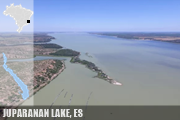
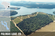
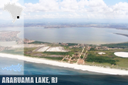
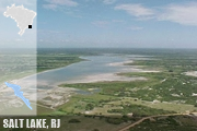
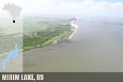
Brazil has a very scarce number of lakes, the vast majority small and without substantial representation; in short, the types that stand out the most are coastal lagoons. We list here the six of the most prominent in the country. Araruama Lake in Rio de Janiero state is the largest body of permanent hypersaline water in the world, with 220 km², surpassing other prominent hypersaline water bodies such as the Great Salt Lake (United States), Lake Coorong (Australia), Lake Enriquillo (Dominican Republic) and the Lagoon Ojo de Liebre in Mexico (Wikipedia), and the second largest salttwater lake in country and the largest enterely within. Juparanã Lake in Espírito Santo state is the largest (62.58 km², Amorim Gonçalves, Dissertation, 2015) and most volumous (0.5281 km³, estimative of Almanaque Z, SEE) freshwater lake enterely in Brazil, and second of both features in country, in both cases after Mirim Lake. Palmas Lake in Espírito Santo state has maximum depth of 50.7 m, a volume of 0.22 km³ and a mean depth of 21.4 m, being the deepest natural lake in Brazil (Plos One, 2014). Mirim Lake is a freshwaater lake, the largest lake in Brazilian territory, with average are c. 3,749 km² (3,381 - 3,863 km²), c. 2/3 in Brazil and 1/3 in Uruguay (Wikipedia); has an average depth of 4.5 m (Munar et al., SBRH, 2017; maximous of 16m), accumulating, based on these numbers, a average of volume of 16.87 km³ (IPH, 1998). Mangueira Lake is a saltwater in SE Rio Grande do Sul state has c. 820 km² and c. 0.7 km³ of volumen, the largest saltwater lake for Brazil (Artioli et al., Iheringia, 2009). Salgado's Lake in northern Rio de Janeiro state contains the unique ocurrence of recent columnar carbonate stromatolites of whole of Brazil and probably of the South America (SIGEP)
IMAGES, LOCATION AND SHAPE OF 5 MOST NOTABLE LAKES IN BRAZIL
SUBTERRANEAN WATERS
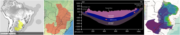
Guarani Aquifer System (GAS) represents the second largest aquifer in the world (after Great Artesian Basin, in Australia, SEE) and the largest in Brazil, occupying 950,000 km² within the Paraná sedimentary basin at 8 states, reaching also in other three countries: Argentina, Paraguay, and Uruguay; 90 M people are directly or indirectly benefitting from the GAS exploitation (Teramoto, Gonçalves & Chang, Journal of Hydrology: Regional Studies, 2022).
 GUARANI AQUIFER CARD
FRESHWATER ECORREGIONS
426 freshwater ecoregions cover virtually the entire non-marine surface of the earth (MAP), 24 in Brazil, the smallest in Brazil is the Chaco, with a small portion in Mato Grosso do Sul state.
BRAZILIAN CLIMATE ‣ despite the wide latitude and the relative variety of temperatures and rainfall rates throughout the national territory, Brazil is not a country of climatic extremes. In few words, the south of the country has higher records of cold temperatures, while the northeast has a history of low rainfall.
The driest place of Brazil is possibly Cabaceiras municiality in Paraíba state, with an average of 336.6 mm with 86 years of observations; during the 86 years studied the total annual extreme rainfall were recorded in the year 1964 in which it rained 775.5 mm and 1952 when the annual total recorded was 23.8 mm (Carmem T. Breckam et al., Rev. Educ. Agrícola Superior, 2013). The rainest place in Brazil in Calçoene municipality, in Amapá state, with 4,165mm rainfall by year (EMBRAPA). Brazil is the 43th rainest country worldwide, with a average by year/by area of 1,761mm (Global Economy). Oliveira, L.L. et al. (IEPA/AP, 2007), analyzing data from station 825002 in Calçoene, between 1975 and 2006, found an average of 4,238.3mm annually, above the value most commonly reported for the point.
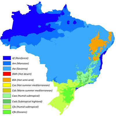
 KÖPPEN CLIMATE TYPES OF BRAZIL
The highest temperature officially registered in Brazil was 44.8 °C (112.6 °F) in Araçuaí, Minas Gerais state, on 19 November 2023 (G1); the lowest temperature officially recorded in Brazil was −14 °C (7 °F) in Caçador, Santa Catarina state, on 11 June 1952 (CIRAN/EPAGRI). There are frosts south of the Tropic of Capricorn during the winter (June–September). The coudest municipality in Brazil is Urupema, Santa Catarina state.
 ANNUAL CLIMATOLOGICAL NORMALS OF TEMPERATURE AND PRECIPITATION FROM 1991 TO 2020 IN BRAZIL (INMET)
Brazil's cold record is less extreme than that of mostly tropical countries like Botswana, Mexico, Peru and Australia; in turn, the heat record is less extreme than that of essentially temperate non-desert countries such as Azerbaijan, Myanmar, Nepal, Turkey, Bosnia and Herzegovina, Bulgaria, Cyprus, France, Greece, Italy, North Macedonia, Portugal, Russia, Serbia, Spain, Canada, as well as the records of Argentina, Bolivia, Paraguay and Guatemala (Wikipedia).
Brazil no has true deserts (1/10 are semi-arid in NE region), however in 2023, research by Cemaden and Inpe identified in the historical series the first region with a truly arid climate in Brazil (CEMADEN), a area of 5,763 km² and is located in the center-north of Bahia and covers the entire area of the cities of Abaré, Chorrochó and Macururé, in addition of area of Curaçá, Juazeiro and Rodelas, municipalities in Bahia that border the Pernambuco hinterland, with an aridity index of less than 0.2 (G1).
 ARID REGIONS WORLDWIDE AND BRAZILIAN SEMIARID REGION
Snow in Brazil often happens in winter in the mountains of Rio Grande do Sul, Santa Catarina, and Paraná, and is rarer at lower elevations. It is possible, but very rare, in the states of São Paulo, Rio de Janeiro, Minas Gerais, and Mato Grosso do Sul. The greatest snowfall recorded in the country occurred in Vacaria on 7 August 1879, when more than 2m of snow accumulated on the ground. Other significant snowfalls where more than 1m of snow accumulated happened on 20 July 1957 in São Joaquim and 15 June 1985, in Pico das Agulhas Negras. São Joaquim has the most snowy days of any settlement in Brazil. Snow has been recorded in Curitiba during several years, but has not accumulated significantly since 1975. In 2013, snow hit several municipalities, including Curitiba. Snow has also occurred in Porto Alegre, but is very rare (Wikipedia).
SNOW IN BRAZIL:
ITAMONTE/MG (JUN 85, SEE), GUARAPUAVA/PR (JUL 2013, SEE),
S.JOAQUIM/SC (AGO 2010, SEE), CAXIAS DO SUL/RS (AGO 2013, SEE)
Because the South Atlantic basin is generally not a favorable environment for their development, Brazil has only rarely experienced tropical cyclones. The country's coastal population centers are considered less burdened with the need to prepare for cyclones, as are cities at similar latitudes in the United States and Asia. In 2011, the Brazilian Navy Hydrographic Center started assigning official names to tropical and subtropical cyclones that develop within its area of responsibility, which is to the west of 20°W, when they have gained sustained wind speeds of 65 km/h and over. Hurricane Catarina is the first and only South Atlantic tropical cyclone to have reached hurricane strength, and impacted Santa Catarina as a Category 2 storm in March 28, 2004. It reached sustained wind speeds of 155 km/h and a pressure of 972 millibars. The hurricane damaged shipyards and several crop fields, and poorer people were affected the most. At least 2,000 people became homeless as a result of the storm (Wikipedia)
 HISTORIC SERIES OF HURRICANES, IMAGE AND WAY OF OF CATARINA HURRICANE, UNIQUE IN RECENT HISTORY OF BRAZIL
'Flying rivers' are air currents that bring water vapour from Amazonia, in the equatorial zone of Northern South America, down as far south as Northern Argentina. The humidity carried by these “airborne rivers” is responsible for much of the rain that falls in the Centre-West, Southeast and South of Brazil. Amazing as it might seem, the quantity of water transported by the flying rivers could well be equivalent to or even greater than the flow of the mighty Amazon itself. Total amount of water released into the atmosphere every day by the rainforest at around 20 B tonnes. This compares interestingly with the total volume of water discharged daily (at a rate of 200,000 m³/s) into the Atlantic by the Amazon River: 17 B tonnes. (riosvoadores.com).
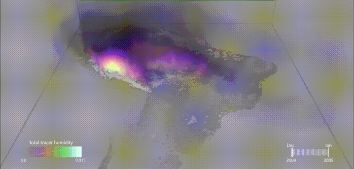 FLYING RIVERS' IN SOUTH AMERICA BETWEEN DECEMBER AND JANUARY
A dust storm, also called a sandstorm, is a meteorological phenomenon common in arid and semi-arid regions. Dust storms arise when a gust front or other strong wind blows loose sand and dirt from a dry surface. Fine particles are transported by saltation and suspension, a process that moves soil from one place and deposits it in another (Wikipedia). Although Brazil is not an arid country, dust storms have been recorded more frequently in recent decades. The phenomenon intensified especially after the severe drought of 2022, when large areas of São Paulo, Mato Grosso do Sul, and Minas Gerais were affected. Cities such as Três Lagos (MS, Oct 2021, Último Segundo), Morro Agudo (SP, Oct 21, Climatempo), Ribeirão Preto (SP, Sept 2021, YT) and Franca (SP, Sept 2021, YT), were among those impacted by these storms.
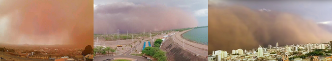 SOME SAND STORMS IN BRAZIL (Morro Agudo (SP, Oct 21, SEE) | Três Lagos (MS), Oct 21, SEE| Franca (SP), Set 21, VIDEO)
Lightning in New World are centered in NW South America (Ecuador to Venezuela) and Chaco region from Argentina to Paraguay. In Brazil, the hottest point is Mato Grosso do Sul region. Worldwide, central Africa is the highest frequency of lightnig worldwide. The second world’s greatest extent for a single lightning flash is a single flash that covered a horizontal distance of 709 ± 8 km across parts of southern Brazil on 31 October 2018 (WHO).
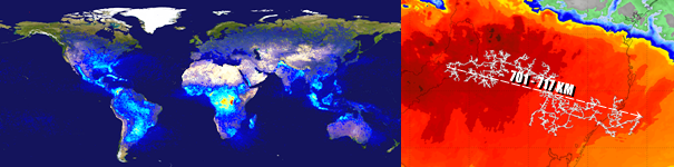 WORLD MAP OF LIGHTNING ACTIVITY BETWENN 1995 TO 2002 (NASA) AND MAP OF THE SECOND MEGAFLASH LIGHTNING EVE RECORDED (PUBLIC/WMO)
VEGETATION MOSAIC ‣ a common discussion in geography is the analysis of a region's vegetation. Here, we focus on ecoregions—large areas of land or water that contain a geographically distinct assemblage of species, natural communities, and environmental conditions (WWF). For a comprehensive map of terrestrial and marine ecoregions, visit images.takeshape, and for an official reference, see the article published in BioScience (2017, SEE).
 |
| BRAZILIAN VEGETATION FORMATIONS |
The world has approximately 40,589,000 km² of forests, with about 1/5 of this area in South America and one-eighth in Brazil, which covers 4,966,200 km², making it the 3ª largest forest cover globally, primarily in the Atlantic Coast and Amazon regions (Wikipedia). According to this reference, between 1990 and 2020, Brazil lost 922,780 km² of forests, approximately 15.66% of its total forest cover. Brazil also boasts the largest number of tree species globally, with 8,715 species, and leads in endemic tree species, with 4,226 species (BGCI). The tallest tree in Brazil and South America is Dinizia excelsa Ducke (Fabaceae), which reaches an astonishing 88.5 meters in height. This specimen, located in a remote area of the Paru State Forest in Pará, is the 10th tallest tree in the world, the second tallest in the tropical region, the largest non-Malvid angiosperm, and the largest angiosperm in the New World (Siderasis).

|
|
TROPICAL FORESTS IN SOUTH AMERICA, SOME DATA, DISTRIBUTION OF DINIZIA EXCELSA AND ARAUCARIA ANGUSTIFOLIA |
BIODIVERSITY ‣ Brazil is one of the most biodiverse countries in the world, a situation largely favored by the fact that it has the largest area in the tropical zone of the entire planet. The following is a general synopsis of the national diversity in the two most notorious groups: vascular plants and animals.
ANIMAL DIVERSITY
With data from the Brazilian Metazoa website (SEE) in March 05, 2025, Brazil has 126,600 spp. of animals in 26,470 genera, these belonging to 3,436 families at 30 phylla. c. 3/4 of the animals in Brazil are insects, distributed in 15,737 genera and 685 families. Brazilian insects represents 1/13 of the world's animal diversity. Some numbers in Brazil includes 91,099 Insecta, 9,093 Arachnida, 4,792 Actinopteri, 2,737 Gastropoda, 1,679 breed birds, 1,675 Neodermata and 1,429 Nematoda, among others. Coast of Brazil includes 1,837 Gastropoda, 1,197 Annelida, 769 Cnidaria, 545 sponges, 347 Echinodermata and 330 Bryozoa. Brazilian freshwaters includes 3,502 fishes, 117 Gastropoda, 116 Bivavia, 61 Tardigrada, 53 sponges, 16 Bryozoa and 7 Cnidaria, among others.
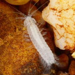
Brazil has 678 spp. of troglobitic species in March 05, 2025 (exclusive and adapted to caves, SEE), being the 4th richest in the world outside Europe (after U.S.A., Australia and China), in several groups, being one of the few countries with species in some phyla, such as Porifera and Onychophora, in addition to other smaller groups, such as Bivalvia.
Vertebrates are the most emblematic groups to discuss fauna. Brazil has the greatest diversity of freshwater fish (3,512) and amphibians (1,253), 2th for mammals (648), 3th for breeding birds (1,742) and reptiles (820), but only 21th for marine fish (1,241), by Brazilian Metazoa (SEE) in June 09, 2023. For endemic species in these groups, Brazil also has the greatest diversity in freshwater fish (2,378) and amphibians (862), 3th for birds (263) and mammals (258), 5th for reptiles (426), and 10th for marine fish (107), by Intreasures (SEE) in March 05, 2025. Brazil is the world's hotspot for miniaturized vertebrates, with the smallest members in continental New World of reptiles (Coleodactyus natalensis) and freshwater fish (Leptophylipnion fittkaui, L. pusillus) from across continental America being endemic to Brazil (Almanaque Z). Brachycephalus dacnis Toledo, Botelho, Carrasco-Medina, Gray, Ernetti, Gama, Lyra, Blackburn, Nunes, and Muscat, 2024 from coastal forests from NE São Paulo and SW Rio de Janeiro states in SE Brazil is among the smallest known vertebrate worldwide (Toledo et al., PeerJ, 2024).
Finally, 21 animal families are endemic to Brazil, the 8ª amount worldwide: Tiguassuidae (1/1, Annelida Clitellata), Arecoidae 1/1, Clitellata), Brazilobatidae (1/1, Acari Sarcoptiformes), Brasileirinidae (1/1, Isopoda), Magnovidae (1/1, Amphipoda), Dobrodesmidae (1/1, Diplopoda), Jurasaidae (2/5, Coleoptera), Melanemerellidae (1/1, Ephemeroptera), Neotheoridae (1/1, Lepidoptera), Bahiaxenidae (1/1, Strepsiptera), Bouchardiidae (1/1, Brachiopoda), Jebramellidae (1/1, Bryozoa), Tapajosellidae (1/1, Bryozoa), Cyclorhamphidae (3/37, Amphibians), Neblinaphrynidae (1/2, Amphibians), Tarumaniidae (1/1, Actinopteri, freshwater), Spintherobolidae (2/5, Actinopteri, freshwater), Plusculidae (1/1, Gastropoda), Euryleptididae (1/1, Platyhelminthes), Acanthocollaritrematidae (1/1, Platyhelminthes) and Braunotrematidae (1/1, Platyhelminthes).
|
|
|
|
|
|
|
|
|
|
|
|
|
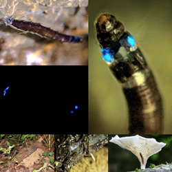
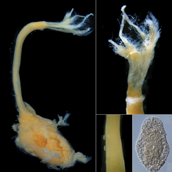
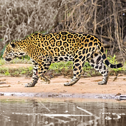
| Mussimilia brasiliensis Verrill, 1868 (Cnidaria, endemic to coast of Bahia state) / Potiicoara brasiliensis Pires, 1987, 1987 (Spelaeogriphidae, troglobic in MT/MS states) / Neoceroplatus betaryiensis Falaschi, Johnson & Stevani, 2019 (Keroplatidae, known only São Paulo state, unique fungus-gnath in Neotropics / Mesembrinus interpunctus Martens, 1887 (Bulimulidae, endemic to SE Brazil) / Osedax nataliae Gularte, Sumida, Bergamo & Rouse, 2024 (Annelida, knwon from 500m deep seas off coast of São Paulo state) / Bolitoglossa paraensis Unterstein, 1930 (Caudata, endemic to N Brazil) / Panthera onca L. (Mammalia, Carnivora).
|
Notably, in two emblematic groups for tropical landscapes, Brazil has the greatest known diversity: primates (102 spp. in 19 genera, 4 of these endemic genera, all in Atlantic Forest, a large near endemic genera (Mico), and almost all Primate genera in New World except Oreonax, endemic to Peru) and parrots (Psittacidae, 83 spp. in 21 genera, 3 of them endemics) - data from Brazilian Brazilian Metazoa (SEE).
REMARKABLE HABITATS
Chemosynthetic ecosystems are fueled by reduced compounds (CH4 and/or H2S), which are important for the chemosynthetic production by microbiota. They comprise hydrothermal vents (absents in Brazil), cold seeps, sulfide-rich seeps, methane-rich seeps, and large organic 'islands' or patches, such as whale skeletons and wood falls (a high accurate map until date of publication is available in German et al., Plos One, 2011). All chemosynthetics Brazilian habitats runs in coast from Espírito Santo to Rio Grande do Sul states (Sumida et al., Springer, 2020, pg. 109): one cold seep off Rio Grande do Sul state at c. 1,300 m depth (details in Leeuwenhoek, Springer, 2017); one disconected asphalt/oil sheep off Espírito Santo and Rio de Janeiro states (details in Freite et al., Deep Sea Research article 1, 2017, and Fujikura et al., Deep Sea Research article 2, 2017); and a natural whale falls off Santa Catarina state (details in Sumida et al., Scientific Reports, 2016).
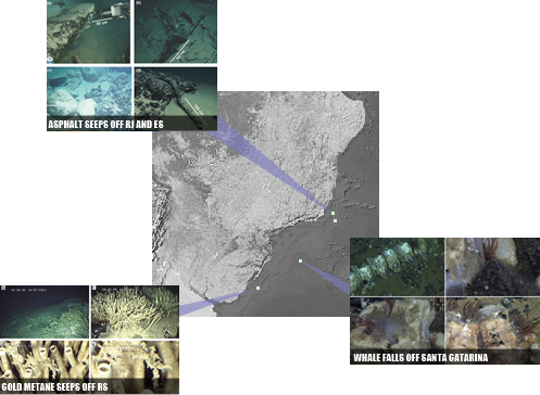 NATURAL CHEMOSYNTHETIC PLACS INSIDE BRAZILIAN EEZ: COLDS SEEPS, WHALE FALLS AND ASPHALT SEEPS
Brazil has the largest know latitudinal occurrence of rhodolith beds (communities dominated by free living, calcareous, non-geniculate coralline algae) in World, from 2°N to 25°S, covering an extension of 4,000 km from Pará down to Rio de Janeiro states (Amado-Filho & Pereira-Filho, Braz. J. Pharmacogn., 2012).
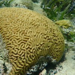
Brazilian coral reefs are one of the most prominent marine ecosystems, comprising the largest and the richest area of reefs in the entire southwestern Atlantic Ocean. These reefs are spread over 3,000 km along the Brazilian coast, from 0º50'S to 18º00'S, and they can be generally divided into the following four main reef regions: the northern region, the reefs of the northeastern coast, the reefs of the eastern coast and the reef ecosystems of the oceanic islands; however, certain coral species are also found on the southeastern and southern coasts of Brazil. These reefs are composed of shallow bank reefs attached to the coast, fringing reefs bordering island shores, coral knolls, patch reefs, isolated bank reefs of different forms and sizes off the coast, and coral pinnacles known as the Brazilian 'chapeirões' (Leão, Z.M.A.N. et al., Brazilian Journal of Oceanography, 2016).
 WORLD AND BRAZILIAN CORALS (MAP) AND COASTAL LANDSCAPE IN TODOS OS SANTOS BAY
Despite its extreme diversity of habitats, Brazil has no fauna associated with hydrothermal vents (SEE), true hibernators (associated to extreme coud climates), or troglobics in anchialine caves or lava tubes.
VASCULAR PLANTS
According to the VPA, as of September 22, 2022, Brazil had 34,780 spp. of vascular plants, including 1,206 of Monilophytes (3ª diversity worldwide), following China (2,124) and Colombia (1,428). Additionally, Brazil hosts 171 spp. of Lycophytes, 24 of Gymnosperms, and 33,379 of Angiosperms, making it the most diverse country for angiosperms (SEE).
All 33,379 species of Brazilian angiosperms are distributed across 2,744 genera and 225 families. The country has 358 endemic genera (SEE), ranking second globally (Intreasures), and boasts the highest number of endemic tree species, with 4,226 species (BGCI). Furthermore, Brazil is home to 133 species of carnivorous plants, 61 species of mycoheterotrophs, 304 species of parasitic plants, and six species of seagrasses (Siderasis).
Miconia (Ruiz & Pav.) has 577 spp. in Brazil, the highest number of species within a single genus in any New World country and fifth worldwide, after Erica in South Africa, Astragalus in Iran, Eucalyptus and Acacia in Australia) (Rankings). The largest genus endemic to Brazil is Neoregelia (Bromeliaceae), with 114 spp., making it the largest endemic genus in the New World and the largest outside South Africa and Australia (Rankings).
Additionally, Brazil ranks third worldwide in Cactaceae diversity (258) and Orchidaceae (2,733) while holding the largest global diversity of Arecaceae (palms), with 266 species across 36 genera (VPA, SEE).
Brazil's flora does not include some extremely notable plant types, such as Fagales, true cushions, gypsophilous plants, Astragalus, mycoheterotrophic Ericaceae, succulent Asclepiadoideae or Crassulaceae, among many others.